Brown County, Minnesota facts for kids
Quick facts for kids
Brown County
|
|
|---|---|

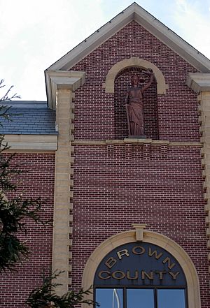
Brown County Courthouse
|
|

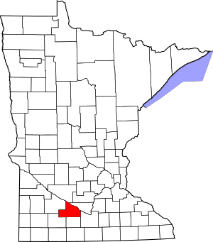
Location within the U.S. state of Minnesota
|
|
 Minnesota's location within the U.S. |
|
| Country | |
| State | |
| Founded | February 20, 1855 (created) 1856 (organized) |
| Named for | Joseph Renshaw Brown |
| Seat | New Ulm |
| Largest city | New Ulm |
| Area | |
| • Total | 618 sq mi (1,600 km2) |
| • Land | 611 sq mi (1,580 km2) |
| • Water | 7.4 sq mi (19 km2) 1.2%% |
| Population
(2020)
|
|
| • Total | 25,912 |
| • Estimate
(2023)
|
25,628 |
| • Density | 41.9/sq mi (16.2/km2) |
| Time zone | UTC−6 (Central) |
| • Summer (DST) | UTC−5 (CDT) |
| Congressional district | 1st |
Brown County is a county in the U.S. state of Minnesota. As of the 2020 census, the population was 25,912. Its county seat is New Ulm. The county was formed in 1855 and organized in 1856.
Brown County comprises the New Ulm, MN Micropolitan Statistical Area and is included in the Mankato-New Ulm-North Mankato, MN Combined Statistical Area.
Contents
History
Brown County was founded in 1855 in the southwest corner of what was Minnesota Territory. It was named for Joseph Renshaw Brown, a member of the Governor's Council of the Territory in 1855. In 1857, Brown County was divided, creating Cottonwood, Jackson, Martin, Murry, Nobles, Pipestone, and Rock counties. Watonwan was broken off in 1860. Redwood was created from a large portion of Brown County in 1862. Redwood was further divided into Lac qui Parle, Lincoln, Lyon and Yellow Medicine Counties in the 1870s.
In 1862, the county's 150-mile northern border was the boundary line of the Upper and Lower Sioux reservations when the 1862 Dakota War broke out. New Ulm, the county seat, came under heavy attack twice by a superior Mdewakanton Dacotah force that was repulsed. Most of the town was torched and most of the population fled to St. Peter and Mankato. The town took many casualties, with the dead buried in the streets. In 1863, when the treaties with the eastern Dacotah were annulled and the two reservations were dissolved, the county border was moved north 10 miles to the Minnesota River.
Geography
The Minnesota River flows east-southeast along the county's northern border. The Cottonwood River flows east-northeast through the county's central and upper area, discharging into the Minnesota at the northern border. The Little Cottonwood River flows east through the lower portion of the county, on its way to discharge into the Minnesota in neighboring Blue Earth County. The terrain consists of rolling hills, mostly devoted to agriculture, and generally slopes to the east, tending to drop into the river valleys. Its highest point is at its southwestern corner, at 1,263 ft (385 m) ASL.
The county has an area of 618 square miles (1,600 km2), of which 611 square miles (1,580 km2) is land and 7.4 square miles (19 km2) (1.2%) is water.
Transit
- Hermann Express
Major highways
Adjacent counties
- Nicollet County - northeast
- Blue Earth County - southeast
- Watonwan County - south
- Cottonwood County - southwest
- Redwood County - west
- Renville County - northwest
Lakes
Most of the county is an area of rich farm land; most of its wetlands were drained for use in agriculture, leaving a number of lakes. The county has at least 32 lakes, some of which are deemed to be "protected waters" of the State of Minnesota; these are designated with "(p)" below.
The lakes occupy "hollows in the driftsheet"; many have neither an inflow nor an outflow.
Lakes in the county include:
- Altermatt Lake (p)
- Bachelor Lake (p), in Stark township
- Boise Lake (p)
- Clear Lake (p)
- Gilman Lake (p)
- Horseshoe Lake
- Juni Lake (p), named for Benedict Juni, a Swiss settler.
- Lake Cottonwood (p)
- Lake Hanska (p)
- Linden Lake (p)
- Lone Tree Lake (p)
- Omsrud Lake (p)
- School Lake (p), named for its location in school section 16.
- Sleepy Eye Lake (p)
- Zanders Lake (p)
Climate and weather
In recent years, average temperatures in the county seat of New Ulm have ranged from a low of 6 °F (−14 °C) in January to a high of 83 °F (28 °C) in July, although a record low of −37 °F (−38 °C) was recorded in January 1984 and a record high of 105 °F (41 °C) was recorded in July 1988. Average monthly precipitation ranged from 0.64 inches (16 mm) in January to 4.82 inches (122 mm) in June.
Demographics
2020 Census
| Race | Num. | Perc. |
|---|---|---|
| White (NH) | 23,968 | 92.5% |
| Black or African American (NH) | 118 | 0.5% |
| Native American (NH) | 39 | 0.2% |
| Asian (NH) | 126 | 0.5% |
| Pacific Islander (NH) | 6 | 0.02% |
| Other/Mixed (NH) | 484 | 1.9% |
| Hispanic or Latino | 1,171 | 4.52% |
Communities
Cities
- Cobden
- Comfrey (partial)
- Evan
- Hanska
- New Ulm (county seat)
- Sleepy Eye
- Springfield
Census-designated place
Unincorporated communities
- Essig
- Godahl (partial)
- Leavenworth
Townships
- Albin Township
- Bashaw Township
- Burnstown Township
- Cottonwood Township
- Eden Township
- Home Township
- Lake Hanska Township
- Leavenworth Township
- Linden Township
- Milford Township
- Mulligan Township
- North Star Township
- Prairieville Township
- Sigel Township
- Stark Township
- Stately Township
See also
 In Spanish: Condado de Brown (Minnesota) para niños


