Broadwater County, Montana facts for kids
Quick facts for kids
Broadwater County
|
|
|---|---|

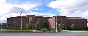
The Broadwater County Courthouse in Townsend
|
|

Location within the U.S. state of Montana
|
|
 Montana's location within the U.S. |
|
| Country | |
| State | |
| Founded | 1897 |
| Named for | Charles Arthur Broadwater |
| Seat | Townsend |
| Largest city | Townsend |
| Area | |
| • Total | 1,239 sq mi (3,210 km2) |
| • Land | 1,193 sq mi (3,090 km2) |
| • Water | 46 sq mi (120 km2) 3.7% |
| Population
(2020)
|
|
| • Total | 6,774 |
| • Estimate
(2022)
|
7,793 |
| • Density | 5.4673/sq mi (2.1109/km2) |
| Time zone | UTC−7 (Mountain) |
| • Summer (DST) | UTC−6 (MDT) |
| Congressional district | 2nd |
|
|
Broadwater County is a county in the U.S. state of Montana. As of the 2020 census, the population was 6,774. Its county seat is Townsend. The county was named for Charles Arthur Broadwater, a noted Montana railroad, real estate, and banking magnate.
Contents
History
The Lewis and Clark Expedition traveled through what is now Broadwater County as they traced the Missouri River. Gold was discovered in the Big Belt Mountains in 1864 which brought several mining towns. In 1881 the Northern Pacific Railway included a stop in what is now Townsend.
Geography
According to the United States Census Bureau, the county has a total area of 1,239 square miles (3,210 km2), of which 1,193 square miles (3,090 km2) is land and 46 square miles (120 km2) (3.7%) is water.
The boundaries of the county are roughly formed by the Big Belt Mountains to the east and north, the Elkhorn Mountains to the west, and the Horseshoe Hills to the south.
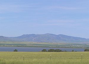
Broadwater County is perhaps best known as the home of Canyon Ferry Lake, the third largest body of water in Montana. The lake provides essential irrigation to local farms, and serves as a recreation destination for the region, with fishing, boating, swimming, camping, and wildlife viewing opportunities.
Major highways
Adjacent counties
- Meagher County - east
- Gallatin County - south
- Jefferson County - west
- Lewis and Clark County - northwest
National protected area
- Helena National Forest (part)
Demographics
| Historical population | |||
|---|---|---|---|
| Census | Pop. | %± | |
| 1900 | 2,641 | — | |
| 1910 | 3,491 | 32.2% | |
| 1920 | 3,239 | −7.2% | |
| 1930 | 2,738 | −15.5% | |
| 1940 | 3,451 | 26.0% | |
| 1950 | 2,922 | −15.3% | |
| 1960 | 2,804 | −4.0% | |
| 1970 | 2,526 | −9.9% | |
| 1980 | 3,267 | 29.3% | |
| 1990 | 3,318 | 1.6% | |
| 2000 | 4,385 | 32.2% | |
| 2010 | 5,612 | 28.0% | |
| 2020 | 6,774 | 20.7% | |
| 2022 (est.) | 7,793 | 38.9% | |
| U.S. Decennial Census 1790–1960, 1900–1990, 1990–2000, 2010–2020 |
|||
2020 census
As of the 2020 census, there were 6,774 people living in the county.
2010 census
As of the 2010 census, there were 5,612 people, 2,347 households, and 1,614 families living in the county. The population density was 4.7 inhabitants per square mile (1.8/km2). There were 2,695 housing units at an average density of 2.3 units per square mile (0.89 units/km2). The racial makeup of the county was 96.2% white, 1.3% American Indian, 0.3% black or African American, 0.2% Pacific islander, 0.2% Asian, 0.3% from other races, and 1.5% from two or more races. Those of Hispanic or Latino origin made up 2.2% of the population. In terms of ancestry, 38.7% were German, 16.2% were English, 15.5% were Irish, 7.9% were Norwegian, 6.4% were Scottish, and 2.3% were American.
Of the 2,347 households, 27.5% had children under the age of 18 living with them, 58.7% were married couples living together, 6.2% had a female householder with no husband present, 31.2% were non-families, and 26.6% of all households were made up of individuals. The average household size was 2.37 and the average family size was 2.85. The median age was 45.4 years.
The median income for a household in the county was $44,667 and the median income for a family was $46,949. Males had a median income of $34,500 versus $32,014 for females. The per capita income for the county was $19,606. About 5.8% of families and 10.1% of the population were below the poverty line, including 10.0% of those under age 18 and 7.1% of those age 65 or over.
Economy
Agriculture is one of the primary industries in Broadwater County. RY Timber and Wheat Montana Bakery were the largest private employers according to the 2000 Census.
Communities
City
- Townsend (county seat)
Census-designated places
Unincorporated communities
- Canton
- Copper City
- Diamond City
- Eustis
- Holker
- Lombard
Former communities
Education
There are three school districts:
- Townsend K-12 Schools
- Three Forks Elementary School District
- Three Forks High School District
The elementary and high school district are both a part of Three Forks Public Schools.
See also
 In Spanish: Condado de Broadwater para niños


