Brenne (river) facts for kids
Quick facts for kids Brenne |
|
| River | |
|
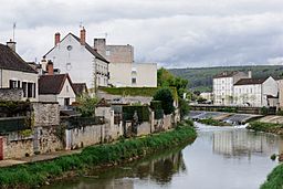
The Brenne river in Montbard
|
|
| Country | France |
|---|---|
| Region | Bourgogne-Franche-Comté |
| Department | Côte-d'Or |
| Municipalities | Sombernon, Montbard |
| Tributaries | |
| - right | Oze, Ozerain |
| City | Montbard |
| Source | |
| - location | Sombernon, Côte-d'Or, France |
| - elevation | 560 m (1,837 ft) |
| - coordinates | 47°18′50″N 4°42′36″E / 47.31389°N 4.71000°E |
| Confluence | Armançon |
| - location | Buffon, Côte-d'Or, France |
| - elevation | 200 m (656 ft) |
| - coordinates | 47°38′38″N 4°16′34″E / 47.64389°N 4.27611°E |
| Length | 71.7 km (45 mi) |
| Basin | 491 km² (190 sq mi) |
| Discharge | for Montbard |
| - average | 8.19 m³/s (289 cu ft/s) |
The Brenne is a river in eastern France. It is a right tributary of the Armançon river and flows through the Côte-d'Or department in the Bourgogne-Franche-Comté region.
Contents
Geography
The Brenne has a length of 71.7 km (44.6 mi), and a drainage basin with an area of approximately 491 km2 (190 sq mi).
Its average yearly discharge (volume of water which passes through a section of the river per unit of time) is 8.19 m3/s (289 cu ft/s) at Montbard in the Côte-d'Or department.
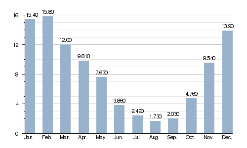 |
| Average monthly discharge (m3/s) at Montbard (1988 - 2017) |
Course
The Brenne starts in the commune of Sombernon, at an elevation of about 560 m (1,837 ft), at about 30 km (19 mi) to the west of Dijon.
It flows to the northwest and joins the Armançon river between the communes Buffon and Montbard at an elevation of about 200 m (660 ft) above sea level.
The Brenne flows through 1 region (Nouvelle-Aquitaine) and 1 department (Côte-d'Or). The river flows through the communes:
- Sombernon
- Aubigny-lès-Sombernon
- Grosbois-en-Montagne
- Vitteaux
- Pouillenay
- Venarey-les-Laumes
- Montbard
- Saint-Rémy
There are only 2 important tributaries, and both join the Brenne on the right side: the Oze and the Ozerain rivers.
Gallery
Related pages
See also
 In Spanish: Brenne para niños


