Breitung Charter Township, Michigan facts for kids
Quick facts for kids
Breitung Township, Michigan
|
|
|---|---|
|
Charter township
|
|
| Charter Township of Breitung | |

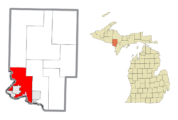
Location within Dickinson County (red) and the administered CDP of Quinnesec (pink)
|
|
| Country | United States |
| State | Michigan |
| County | Dickinson |
| Established | 1876 |
| Area | |
| • Total | 67.89 sq mi (175.83 km2) |
| • Land | 64.27 sq mi (166.46 km2) |
| • Water | 3.62 sq mi (9.38 km2) |
| Elevation | 1,161 ft (354 m) |
| Population
(2020)
|
|
| • Total | 5,831 |
| • Density | 91.1/sq mi (35.2/km2) |
| Time zone | UTC-6 (Central (CST)) |
| • Summer (DST) | UTC-5 (CDT) |
| ZIP code(s) | |
| Area code(s) | 906 |
| FIPS code | 26-10220 |
| GNIS feature ID | 1625974 |
Breitung Charter Township is a charter township of Dickinson County in the U.S. state of Michigan. As of the 2020 census, the township population was 5,831.
Contents
History
The township is named after Edward Breitung, a miner and U.S. Representative from Michigan.
Geography
According to the United States Census Bureau, the township has a total area of 68.3 square miles (177 km2), of which, 65.1 square miles (169 km2) of it is land and 3.2 square miles (8.3 km2) of it (4.70%) is water.
Communities
- The cities of Iron Mountain and Kingsford are in the southwest of the township, but are administratively autonomous.
- East Kingsford is a part of the Kingsford urban area, located in the township just east of the city boundary at 45°47′42″N 88°03′52″W / 45.79500°N 88.06444°W.
- Granite Bluff is an unincorporated community between Meriman and Randville at 45°56′22″N 88°03′13″W / 45.93944°N 88.05361°W.
- Merriman is an unincorporated community on M-95 about seven miles north of Iron Mountain at 45°55′03″N 88°03′20″W / 45.91750°N 88.05556°W
- Quinnesec is an unincorporated community, defined as a census-designated place in the township, just east of Kingsford and Iron Mountain.
- Skidmore is an unincorporated community.
Demographics
| Historical population | |||
|---|---|---|---|
| Census | Pop. | %± | |
| 2000 | 5,930 | — | |
| 2010 | 5,853 | −1.3% | |
| 2020 | 5,831 | −0.4% | |
| U.S. Decennial Census | |||
As of the census of 2000, there were 5,930 people, 2,354 households, and 1,727 families residing in the township. The population density was 91.1 inhabitants per square mile (35.2/km2). There were 2,601 housing units at an average density of 40.0 per square mile (15.4/km2). The racial makeup of the township was 98.35% White, 0.03% African American, 0.44% Native American, 0.47% Asian, 0.12% from other races, and 0.59% from two or more races. Hispanics or Latinos of any race were 0.44% of the population in 2000. By the 2020 census, its population was 5,831.


