Brazos Country, Texas facts for kids
Quick facts for kids
Brazos Country, Texas
|
|
|---|---|
| Country | United States |
| State | Texas |
| County | Austin |
| Incorporated | 2000 |
| Area | |
| • Total | 2.00 sq mi (5.19 km2) |
| • Land | 1.95 sq mi (5.06 km2) |
| • Water | 0.05 sq mi (0.13 km2) |
| Population
(2020)
|
|
| • Total | 514 |
| • Density | 257.0/sq mi (99.04/km2) |
| ZIP code |
77474
|
| FIPS code | 48-10090 |
| GNIS feature ID | 1923026 |
Brazos Country is a residential community in Austin County, Texas, United States. As of the 2020 census, the population was 514.
Geography
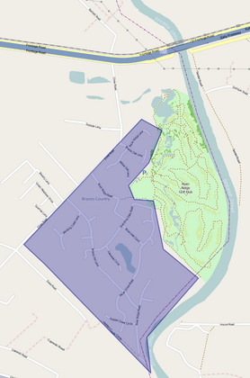
Brazos Country is located south of Interstate 10 and 7 miles (11 km) southeast of Sealy. Downtown Houston is 43 miles (69 km) to the east. The eastern city limits of Brazos Country run along the west bank of the Brazos River. The only entrances to the city are from Chew Road. As of the 2010 census, the population was 469.
There are several small, unnamed bodies of water within Brazos Country, likely manmade.
Brazos Country is located at 29°45′11″N 96°2′17″W / 29.75306°N 96.03806°W. According to the United States Census Bureau, the city has a total area of 5.5 square miles (14 km2), of which, 5.4 square miles (14 km2) of it is land and 0.1 square miles (0.26 km2) is water.
| Historical population | |||
|---|---|---|---|
| Census | Pop. | %± | |
| 2010 | 469 | — | |
| 2020 | 514 | 9.6% | |
| U.S. Decennial Census 2020 Census |
|||
History
Development of the area began in the late 1970s, and the city was incorporated in May 2000.
See also
 In Spanish: Brazos Country para niños


