Bortigali facts for kids
Quick facts for kids
Bortigali
Bortigale
|
|
|---|---|
| Comune di Bortigali | |
 |
|
| Country | Italy |
| Region | Sardinia |
| Province | Province of Nuoro (NU) |
| Frazioni | Mulargia |
| Area | |
| • Total | 67.4 km2 (26.0 sq mi) |
| Elevation | 510 m (1,670 ft) |
| Population
(Dec. 2004)
|
|
| • Total | 1,502 |
| • Density | 22.285/km2 (57.72/sq mi) |
| Demonym(s) | Bortigalesi |
| Time zone | UTC+1 (CET) |
| • Summer (DST) | UTC+2 (CEST) |
| Postal code |
08012
|
| Dialing code | 0785 |
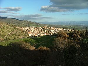
Bortigali (Sardinian: Bortigale) is a comune (municipality) in the Province of Nuoro in the Italian region Sardinia, located about 120 kilometres (75 mi) north of Cagliari and about 45 kilometres (28 mi) west of Nuoro. As of 31 December 2004, it had a population of 1,502 and an area of 67.4 square kilometres (26.0 sq mi).
The municipality of Bortigali contains the frazione (subdivision) Mulargia.
Bortigali borders the following municipalities: Birori, Bolotana, Dualchi, Macomer, Silanus.
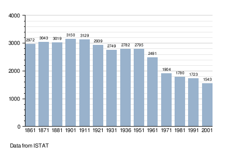
Demographic evolution

Climate
| Climate data for Bortigali | |||||||||||||
|---|---|---|---|---|---|---|---|---|---|---|---|---|---|
| Month | Jan | Feb | Mar | Apr | May | Jun | Jul | Aug | Sep | Oct | Nov | Dec | Year |
| Mean daily maximum °C (°F) | 9 (48) |
10 (50) |
12 (53) |
15 (59) |
19 (66) |
24 (75) |
28 (82) |
28 (82) |
24 (75) |
19 (66) |
13 (55) |
10 (50) |
17 (62) |
| Mean daily minimum °C (°F) | 3 (37) |
3 (37) |
5 (41) |
7 (44) |
10 (50) |
13 (55) |
16 (60) |
17 (62) |
14 (57) |
10 (50) |
7 (44) |
5 (41) |
9 (48) |
| Average precipitation mm (inches) | 99 (3.9) |
110 (4.4) |
81 (3.2) |
71 (2.8) |
38 (1.5) |
33 (1.3) |
5.1 (0.2) |
13 (0.5) |
41 (1.6) |
97 (3.8) |
130 (5.1) |
120 (4.6) |
830 (32.8) |
| Source: Weatherbase | |||||||||||||
See also
 In Spanish: Bortigali para niños

All content from Kiddle encyclopedia articles (including the article images and facts) can be freely used under Attribution-ShareAlike license, unless stated otherwise. Cite this article:
Bortigali Facts for Kids. Kiddle Encyclopedia.
