Binnein an Fhidhleir facts for kids
Quick facts for kids Binnein an Fhidhleir |
|
|---|---|
| (Stob Coire Creagach) | |

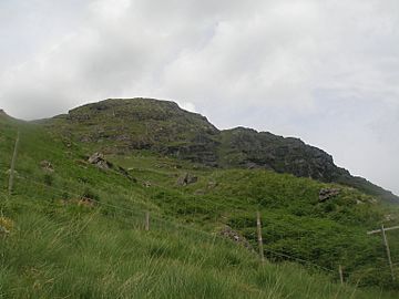
Binnein an Fhidhleir (Stob Coire Creagach top) seen from Butterbridge
|
|
| Highest point | |
| Elevation | 817 m (2,680 ft) |
| Prominence | 504 m (1,654 ft) |
| Parent peak | Beinn Ime |
| Listing | Corbett, Marilyn |
| Naming | |
| English translation | The fiddler's peak (Peak of the rocky corrie) |
| Language of name | Scottish Gaelic |
| Geography | |
| Parent range | Arrochar Alps, Grampian Mountains |
| OS grid | NN230109 |
| Topo map | OS Landranger 56 |
Binnein an Fhidhleir, one of the Arrochar Alps, is a mountain in southern Scotland. It is located above Butterbridge on the north side the A83 road facing Beinn an Lochain to the south. The mountain has several tops, including Creag Bhrosgan (711 m); Stob Coire Creagach, which replaced Binnein an Fhidhleir as the Marilyn in April 2006 at 817 m; one without any name at all at 748 metre; and Binnein an Fhidhleir itself, further to the west, at 811 m. Although Stob Coire Creagach is the highest summit, the name Binnein an Fhidhleir is generally used for the whole mountain.
The shortest route of ascent is directly up the hillside above Butterbridge, where there is a carpark. A number of small crags must be avoided, and the route is steep and unrelenting. Alternatively, the hill may be ascended from further up Glen Kinglas by way of Binnein an Fhidhleir's northern ridge: although longer this route is considerably less steep.


