Bhola District facts for kids
Quick facts for kids
Bhola
|
|
|---|---|

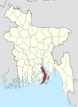
Location of Bhola in Bangladesh
|
|
| Country | |
| Division | Barisal Division |
| Area | |
| • Total | 3,403.48 km2 (1,314.09 sq mi) |
| Population
(2011 Census)
|
|
| • Total | 2,037,201 |
| • Density | 598.5641/km2 (1,550.2739/sq mi) |
| Literacy rate | |
| • Total | 43.2% |
| Time zone | UTC+06:00 (BST) |
| Postal code |
8300
|
| HDI (2018) | 0.586 medium · 16th of 21 |
| Website | www.bhola.gov.bd |
Bhola (Bengali: ভোলা) is a district in south-western Bangladesh. It is in the Barisal Division. It is also the largest offshore island region in Bangladesh, with an area of 3403.48 km². It is bordered by Lakshmipur and Barisal districts to the north. Bay of Bengal is to the south; Lakshmipur and Noakhali districts, Meghna (lower) river and Shahbazpur Channel are to the east. Patuakhali district and Tentulia river are to the west.
Subdistricts
Bhola district comprises the following upazilas:
- Bhola Sadar Upazila
- Burhanuddin Upazila
- Char Fasson Upazila
- Daulatkhan Upazila
- Lalmohan Upazila
- Manpura Upazila
- Tazumuddin Upazila
Places of interest
- Bhola Shishu Park
- Charfashion College
Related pages
Images for kids
-
South Shahbajpur Island ( marked as DECCAN SHABAZPOUR l.) which is now Bhola in 1778 map by James Rennell
See also
 In Spanish: Bhola (zila) para niños

All content from Kiddle encyclopedia articles (including the article images and facts) can be freely used under Attribution-ShareAlike license, unless stated otherwise. Cite this article:
Bhola District Facts for Kids. Kiddle Encyclopedia.


