Bernalillo, New Mexico facts for kids
Quick facts for kids
Bernalillo, New Mexico
|
|
|---|---|
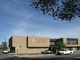
Bernalillo Town Hall, May 2009
|
|
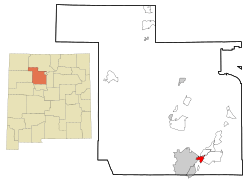
Location of Bernalillo, New Mexico
|
|
| Country | United States |
| State | New Mexico |
| County | Sandoval |
| Founded | 1695 |
| Area | |
| • Total | 5.296 sq mi (13.717 km2) |
| • Land | 5.258 sq mi (13.619 km2) |
| • Water | 0.038 sq mi (0.099 km2) |
| Elevation | 5,053 ft (1,540 m) |
| Population
(2020)
|
|
| • Total | 8,977 |
| • Estimate
(2023)
|
9,114 |
| • Density | 1,733/sq mi (669.2/km2) |
| Time zone | UTC−7 (Mountain (MST)) |
| • Summer (DST) | UTC−6 (MDT) |
| ZIP Code |
87004
|
| Area code(s) | 505 |
| FIPS code | 35-06970 |
| GNIS feature ID | 2411678 |
| Sales tax | 6.94% |
Bernalillo (/ˌbɜːrnəˈliːjoʊ/) is a town in and the county seat of Sandoval County, New Mexico, United States. The population was 8,977 at the 2020 census.
Bernalillo is part of the Albuquerque Metropolitan Statistical Area.
History
Wine Festival
In the 1620s, the wine grape was introduced to Bernalillo by the Catholic priests and Spaniards. The wine industry grew rapidly since. Families were making their own wine and the vineyards were flourishing. The market dipped due to drought and floods. Slowly over time, the wine industry came back into Bernalillo and has sustained its health today, becoming a tradition and staple within the town itself.
The town has embraced its wine heritage and hosts the New Mexico Wine festival yearly during each Labor Day. The event brings in people from all of New Mexico as well as tourists. The event has served as an economic development project for the area as well.
Geography
Bernalillo lies in the Rio Grande Valley of the Albuquerque Basin on the east bank of the Rio Grande. According to the United States Census Bureau, the city has a total area of 5.296 square miles (13.72 km2), of which 5.258 square miles (13.62 km2) is land and 0.038 square miles (0.10 km2), or 2.34% is water
Demographics
| Historical population | |||
|---|---|---|---|
| Census | Pop. | %± | |
| 1880 | 1,223 | — | |
| 1950 | 1,922 | — | |
| 1960 | 2,574 | 33.9% | |
| 1970 | 2,016 | −21.7% | |
| 1980 | 2,988 | 48.2% | |
| 1990 | 5,960 | 99.5% | |
| 2000 | 6,611 | 10.9% | |
| 2010 | 8,320 | 25.9% | |
| 2020 | 8,977 | 7.9% | |
| 2023 (est.) | 9,114 | 9.5% | |
| U.S. Decennial Census 2020 Census |
|||
2020 census
| Race | Number | Percent |
|---|---|---|
| White (NH) | 2,476 | 27.6% |
| Black or African American (NH) | 52 | 0.6% |
| Native American (NH) | 468 | 5.2% |
| Asian (NH) | 66 | 0.7% |
| Pacific Islander (NH) | 6 | 0.1% |
| Some Other Race (NH) | 29 | 0.3% |
| Mixed/Multi-Racial (NH) | 150 | 1.7% |
| Hispanic or Latino | 5,730 | 63.8% |
| Total | 8,977 | 100.0% |
As of the 2020 census, there were 8,977 people, 3,563 households, and 2,367 families residing in the town. The population density was 1,837.7 inhabitants per square mile (709.5/km2). There were 3,801 housing units. The racial makeup of the town was 44.2% White, 0.7% African American, 6.6% Native American, 0.8% Asian, 0.1% Pacific Islander, 24.5% from some other races and 23.1% from two or more races. Hispanic or Latino of any race were 63.8% of the population. 14.7% of residents were under the age of 18, 3.6% were under 5 years of age, and 25.2% were 65 and older.
Education
Most of Bernalillo is in the Bernalillo Public Schools district. Some is in the Jemez Valley Public Schools district. The former operates Bernalillo High School.
Gallery
-
US Route 550 with Sandia Mountains
See also
 In Spanish: Bernalillo para niños


