Belmont, Ohio facts for kids
Quick facts for kids
Belmont, Ohio
|
|
|---|---|
|
Village
|
|

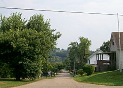
Belmont Historic District
|
|

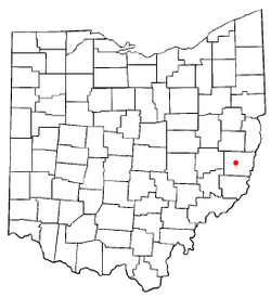
Location of Belmont, Ohio
|
|

Location of Belmont in Belmont County
|
|
| Country | United States |
| State | Ohio |
| County | Belmont |
| Township | Goshen |
| Area | |
| • Total | 0.27 sq mi (0.69 km2) |
| • Land | 0.27 sq mi (0.69 km2) |
| • Water | 0.00 sq mi (0.00 km2) |
| Elevation | 1,188 ft (362 m) |
| Population
(2020)
|
|
| • Total | 414 |
| • Estimate
(2023)
|
404 |
| • Density | 1,556.39/sq mi (600.33/km2) |
| Time zone | UTC-5 (Eastern (EST)) |
| • Summer (DST) | UTC-4 (EDT) |
| ZIP code |
43718
|
| Area code(s) | 740 |
| FIPS code | 39-05312 |
| GNIS feature ID | 2398086 |
Belmont is a village in central Belmont County, Ohio, United States. The population was 414 at the 2020 census. It is part of the Wheeling metropolitan area.
History
Belmont was originally known as Wrightstown, and under the latter name was laid out in 1808 by Joseph Wright. The name was switched to Belmont in anticipation of being the county seat of Belmont County. St. Clairsville, however, was given the honor of having Belmont County's center of government. The Baltimore and Ohio Railroad cut through the town until its dismantling in the 1980s.
Geography
According to the United States Census Bureau, the village has a total area of 0.27 square miles (0.70 km2), all land.
Belmont is also located approximately one mile south of Barkcamp State Park.
The Village is also part of the historic Drover's Trail that winds through the hills and valleys of Belmont County.
Demographics
| Historical population | |||
|---|---|---|---|
| Census | Pop. | %± | |
| 1880 | 319 | — | |
| 1890 | 384 | 20.4% | |
| 1900 | 422 | 9.9% | |
| 1910 | 572 | 35.5% | |
| 1920 | 680 | 18.9% | |
| 1930 | 674 | −0.9% | |
| 1940 | 697 | 3.4% | |
| 1950 | 638 | −8.5% | |
| 1960 | 563 | −11.8% | |
| 1970 | 666 | 18.3% | |
| 1980 | 714 | 7.2% | |
| 1990 | 471 | −34.0% | |
| 2000 | 532 | 13.0% | |
| 2010 | 453 | −14.8% | |
| 2020 | 414 | −8.6% | |
| 2023 (est.) | 404 | −10.8% | |
| U.S. Decennial Census | |||
2010 census
As of the census of 2010, there were 453 people, 197 households, and 129 families living in the village. The population density was 1,677.8 inhabitants per square mile (647.8/km2). There were 218 housing units at an average density of 807.4 per square mile (311.7/km2). The racial makeup of the village was 97.4% White, 0.4% African American, 1.3% Native American, and 0.9% from two or more races. Hispanic or Latino of any race were 0.2% of the population.
There were 197 households, of which 27.9% had children under the age of 18 living with them, 48.7% were married couples living together, 11.2% had a female householder with no husband present, 5.6% had a male householder with no wife present, and 34.5% were non-families. 31.5% of all households were made up of individuals, and 13.2% had someone living alone who was 65 years of age or older. The average household size was 2.26 and the average family size was 2.77.
The median age in the village was 44 years. 20.8% of residents were under the age of 18; 8.7% were between the ages of 18 and 24; 22.9% were from 25 to 44; 31.7% were from 45 to 64; and 15.9% were 65 years of age or older. The gender makeup of the village was 46.1% male and 53.9% female.
Education
Union Local School District.
Faith Community Christian High School. While formerly Belmont Elementary School, it is now home to a private school.
Notable people
- David Clarke, actor
- Nora Dunfee, actor
- Harley Warrick, folk artist and barn painter
See also
 In Spanish: Belmont (Ohio) para niños

