Barima River facts for kids
Quick facts for kids Barima River |
|
|---|---|

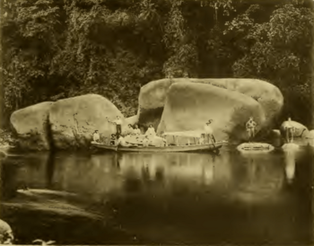
Arawatta Rock in the Barima River
|
|
|
Location of mouth
|
|
| Country | Guyana, Venezuela |
| Physical characteristics | |
| River mouth | 8°35′N 60°25′W / 8.583°N 60.417°W |
The Barima River is a tributary of the Orinoco River, entering 6 kilometres (4 mi) from the Atlantic Ocean. It originates from the Imataka Mountains in Guyana, flowing for approximately 340 kilometres (210 mi) before entering Venezuela about 80 kilometres (50 mi) from its mouth.
Features
Early recorded explorations of the Barima were made by Robert Hermann Schomburgk, which was mapped as far as the tributary Rocky River.
The head of the Barima rises in a steep gorge of the Imataka mountains, 950 ft (290 m) above sea level. Near the Duquari Creek, the Arawatta Rock, a distinct large granite rock, is located.
Settlements
Mabaruma, Koriabo, and Morawhanna are Barima-Waini Region communities on the Barima River.
See also
 In Spanish: Río Barima para niños

All content from Kiddle encyclopedia articles (including the article images and facts) can be freely used under Attribution-ShareAlike license, unless stated otherwise. Cite this article:
Barima River Facts for Kids. Kiddle Encyclopedia.

