Barambah, Queensland facts for kids
Quick facts for kids BarambahQueensland |
|||||||||||||||
|---|---|---|---|---|---|---|---|---|---|---|---|---|---|---|---|

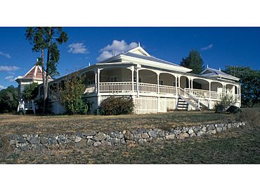
Barambah Homestead
|
|||||||||||||||
| Population | 39 (2021 census) | ||||||||||||||
| • Density | 0.244/km2 (0.63/sq mi) | ||||||||||||||
| Postcode(s) | 4601 | ||||||||||||||
| Area | 160.0 km2 (61.8 sq mi) | ||||||||||||||
| Time zone | AEST (UTC+10:00) | ||||||||||||||
| Location | |||||||||||||||
| LGA(s) | Gympie Region | ||||||||||||||
| State electorate(s) | Nanango | ||||||||||||||
| Federal Division(s) | Wide Bay | ||||||||||||||
|
|||||||||||||||
Barambah is a rural locality in the Gympie Region, Queensland, Australia. In the 2021 census, Barambah had a population of 39 people.
History
Land was open for selection on 17 April 1877; 11,000 acres (4,500 ha) were available in Baramba, 18,500 acres (7,500 ha) in Baramba North, 28 square miles (73 km2) in East Baramba and 4,500 acres (1,800 ha) in the Baramba Ranges.
In July 1906, 32 allotments were advertised for selection by the Department of Public Lands Office. The map advertising the land selection states the allotments are portions in the Parishes of Murgon, Goomeribong and Barambah. The portions were left over from 5 April 1906.
Demographics
In the 2016 census Barambah had a population of 46 people.
In the 2021 census, Barambah had a population of 39 people.
Heritage listings
Barambah has a number of heritage-listed sites, including:
- Goomeri Road: Barambah Homestead


