Banville facts for kids
Quick facts for kids
Banville
|
||
|---|---|---|
|
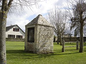
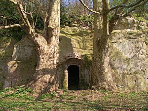
A covered well in Banville
|
||
|
||
| Country | France | |
| Region | Normandy | |
| Department | Calvados | |
| Arrondissement | Bayeux | |
| Canton | Courseulles-sur-Mer | |
| Intercommunality | Seulles Terre et Mer | |
| Area
1
|
4.68 km2 (1.81 sq mi) | |
| Time zone | UTC+01:00 (CET) | |
| • Summer (DST) | UTC+02:00 (CEST) | |
| INSEE/Postal code |
14038 /14480
|
|
| Elevation | 2–53 m (6.6–173.9 ft) (avg. 25 m or 82 ft) |
|
| 1 French Land Register data, which excludes lakes, ponds, glaciers > 1 km2 (0.386 sq mi or 247 acres) and river estuaries. | ||
Banville is a commune in the Calvados department in the Normandy region of north-western France.
The inhabitants of the commune are known as Banvillais or Banvillaises.
Contents
Geography
Banville is located in the Bessin area some 3 km south-west of Courseulles-sur-Mer and 5 km east of Crépon. Access to the commune is by the D12 road from Graye-sur-Mer in the north which passes through the village and continues south-west to Tierceville. The D112A goes west from the village to Sainte-Croix-sur-Mer. The commune is mostly farmland but with a significant sized residential area.
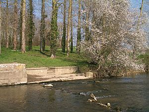
The Seulles river forms the entire eastern border of the commune as it flows north to the English Channel at Courseulles-sur-Mer.
Neighbouring communes and villages
 |
Ver-sur-Mer | Graye-sur-Mer | Bernières-sur-Mer |  |
| Crépon | ||||
| Tierceville | Amblie | Reviers |
History
During the invasion of Normandy Banville was located within 3 kilometres of Juno Beach (Mike sector), the landing zone for Canadian troops. The village was liberated on the 6 June 1944 by the Royal Winnipeg Rifles.
Demography
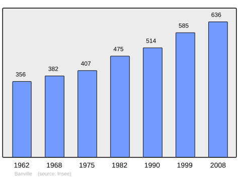
In 2010 the commune had 657 inhabitants. The evolution of the number of inhabitants is known from the population censuses conducted in the commune since 1793. From the 21st century, a census of communes with fewer than 10,000 inhabitants is held every five years, unlike larger communes that have a sample survey every year.
Culture and heritage
Civil heritage
The commune has many buildings and structures that are registered as historical monuments:
- The Reviers Bridge (17th century)

- The Hervot Farmhouse at 12 rue du Bout du Haut (1913)

- A Farmhouse at 25 Rue du Camp Romain (18th century)

- A Notable's House at 8 Rue du Marché (18th century)

- A Lavoir (Public laundry) at Route de Reviers (19th century)

- A Chateau (1545)

- A Girls' Primary School (19th century)

- The old Town Hall (19th century)

- The Village (Neolithic)

- Houses (18th-19th century)

- Other sites of interest
- The Roman Camp of La Burette.
Religious heritage
The commune has several religious buildings and structures that are registered as historical monuments:
- A Presbytery at 10 Rue du Bout du Haut (18th century)

- A Calvary at Route de Courseulles-Sur-Mer (1912)

- The Parish Church of Saint-Lo (18th century)

The Church contains many items that are registered as historical objects:
- A Stole (19th century)

- A Ciborium (18th century)

- A Monstrance (19th century)

- A Way of the Cross (19th century)

- A Chalice with Paten (19th century)

- 3 Processional Banners (19th century)

- A Painting: Nativity (17th century)

- A Statue: Virgin and child (17th century)

- A Statue: Saint Nicolas de Bari (18th century)

- A Cross: Christ on the Cross (18th century)

- 2 banks of Stalls (19th century)

- A Paschal Candlestick (19th century)

- A Rood beam (19th century)

- A Baptismal font (16th century)

- A set of 7 Stained glass windows: Seven Sacrements (1959)

- A set of 6 Stained glass windows (1959)

- The Furniture in the Church

of France.


