Bangsamoro facts for kids
Quick facts for kids
Bangsamoro
|
|||
|---|---|---|---|
|
Autonomous Region
|
|||
| Bangsamoro Autonomous Region in Muslim Mindanao Filipino: Rehiyong Awtonomo ng Bangsamoro sa Muslim Mindanao Arabic: منطقة بانجسامورو ذاتية الحكم فى مسلمى مينداناو |
|||
|
Left to right, top to bottom: Bulingan Falls, Lamitan, Basilan; Sulu Provincial Capitol; Panampangan Island, Sapa-sapa, Tawi-Tawi; Polloc Port, Parang, Maguindanao; Lanao Lake at Marawi City; and PC Hill, Cotabato City
|
|||
|
|||
| Anthem: Bangsamoro Hymn | |||

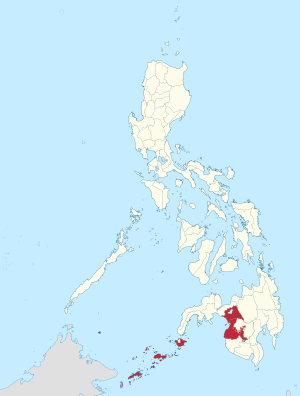
Location in the Philippines
|
|||
| Country | Philippines | ||
| Regional center | Cotabato City (de facto) | ||
| Time zone | UTC+08:00 (PST) | ||
| Provinces | |||
| Cities |
3
Cotabato City
Lamitan Marawi |
||
| Municipalities | 116 | ||
| Barangays | 2,590 (including 63 in the Special Geographic Area in Cotabato) | ||
The Bangsamoro is an autonomous region in the southern Philippines. It is officially named the Bangsamoro Autonomous Region in Muslim Mindanao or BARMM.
It replaced the Autonomous Region in Muslim Mindanao in 2019.
The region includes Lake Lanao, one of the 17 most ancient lakes in the world. The Sulu archipelago region includes the Turtle Islands Wildlife Sanctuary (a UNESCO tentative site), Bongao Peak, and the Basilan Rainforest.
Images for kids
-
Approximate historical extent of the Muslim sultanates of Sulu, Maguindanao and Lanao
-
President Rodrigo Duterte sounds the agung during the inauguration of Bangsamoro. He is joined by Chief Minister Murad Ebrahim.
-
Daru Jambangan (Palace of Flowers) in Maimbung, Sulu before it was destroyed by a typhoon in 1932.
-
Tausūg horsemen in Sulu, taken on December 30, 1899.
-
Pastil, a traditional Maguindanaon food.
See also
 In Spanish: Bangsamoro para niños


