Bío Bío Province facts for kids
Quick facts for kids
Bío Bío Province
Provincia de Bío Bío
|
|||||
|---|---|---|---|---|---|

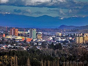
General view of Los Ángeles
|
|||||
|
|||||
| Country | |||||
| Region | Bío Bío | ||||
| Capital | Los Ángeles | ||||
| Comunas | See list | ||||
| Government | |||||
| • Type | Provincial | ||||
| Area | |||||
| • Total | 14,987.9 km2 (5,786.9 sq mi) | ||||
| Population
(2002 Census)
|
|||||
| • Total | 353,315 | ||||
| • Density | 23.57335/km2 (61.05469/sq mi) | ||||
| Time zone | UTC-4 (CLT) | ||||
| • Summer (DST) | UTC-3 (CLST) | ||||
| Website | Official website: http://www.gobernacionbiobio.gov.cl/ | ||||
The Bío Bío Province (Spanish: Provincia de Bío Bío) is one of three provinces of the Chilean region of Bío Bío (VIII). The provincial capital is the city of Los Ángeles.
Geography
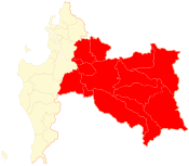
The Bío Bío province is in the southeast of the Bío Bío region with an area of 14,987.9 sq mi (38,818 km2). It is the only province of the region that is not along the coast. The capital, Los Ángeles, is to the southeast of Concepción, the capital of the region.
Bío Bío is bordered to the north by the Ñuble province, to the west by the Concepción province, to the east by Argentina, to the south by the Araucanía region and to the southwest by the Arauco province .
 |
Ñuble province |  |
||
| Concepción province | Argentina | |||
| Arauco province | Araucanía region |
The main river that flows through the province is the Bío Bío.
Climate
The climate of Los Ángeles is a Mediterranean climate, Cfb in the Köppen climate classification.
The average amount of precipitation for the year in Los Ángeles is 1,069.3 mm (42.1 in). The month with the most precipitation on average is May with 254 mm (10.0 in) of precipitation. The month with the least precipitation on average is February with an average of 15.2 mm (0.6 in).
The average temperature for the year in Los Ángeles is 13.9 °C (57.0 °F). The warmest month, on average, is January with an average temperature of 20 °C (68 °F). The coolest month on average is July, with an average temperature of 7.8 °C (46.0 °F).
Population
As of 2002[update] (last national census), there were 353,315 people living in the province, giving it a population density of 23.6 inhabitants/km². The urban population was 245,775 persons (70% of the total).
The largest city of the province, in 2002, is its capital, Los Ángeles, with 117,972 inhabitants. Other cities are Mulchén (21,819 inhabitants) and Nacimiento (20,884 inhabitants).
Administration
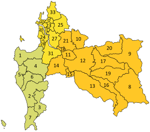
As a province, Bío Bío is a second-level administrative division, consisting of 14 communes (comunas). The city of Los Ángeles serves as the provincial capital. The province is administered by a governor.
| Code | Comuna | Capital | Area (km²) |
Population (2002) |
Density |
|---|---|---|---|---|---|
| 08301 | 12 Los Ángeles | Los Ángeles | 1,748.2 | 166,556 | 95.3 |
| 08302 | 9 Antuco | Antuco | 1,884.1 | 3,908 | 2.1 |
| 08303 | 10 Cabrero | Cabrero | 640.8 | 25,282 | 39.5 |
| 08304 | 11 Laja | Laja | 339.8 | 22,404 | 65.9 |
| 08305 | 13 Mulchén | Mulchén | 1,925.3 | 29,003 | 15.1 |
| 08306 | 14 Nacimiento | Nacimiento | 934.9 | 25,971 | 27.8 |
| 08307 | 15 Negrete | Negrete | 156.5 | 8,579 | 54.8 |
| 08308 | 16 Quilaco | Quilaco | 1,123.7 | 4,021 | 3.6 |
| 08309 | 17 Quilleco | Quilleco | 1,121.8 | 10,428 | 9.3 |
| 08310 | 18 San Rosendo | San Rosendo | 92.4 | 3,918 | 42.4 |
| 08311 | 19 Santa Bárbara | Santa Bárbara | 1,254.9 | 12,943 | 10.3 |
| 08312 | 20 Tucapel | Tucapel | 914.9 | 12,777 | 14.0 |
| 08313 | 21 Yumbel | Yumbel | 727.0 | 20,498 | 28.2 |
| 08314 | 8 Alto Biobío | Alto Biobío | 2,124.6 | 7,027 | 3.3 |
| Total of the Biobío province | 14,987.9 | 353,315 | 23.6 | ||
Related pages
See also
 In Spanish: Provincia de Biobío para niños


