Ayalon Highway facts for kids
Quick facts for kids
Highway 20 |
|
|---|---|
| נתיבי איילון Netivei Ayalon |
|
| Ayalon Highway | |
| Lua error in Module:Infobox_road/map at line 15: attempt to index field 'wikibase' (a nil value). | |
| Route information | |
| Length | 29 km (18 mi) |
| Major junctions | |
| From | Rishon LeZion (Holot Interchange) |
|
|
| North end | Herzliya (Begin Interchange) |
| Location | |
| Major cities: | Holon, Herzliya, Bat Yam, Tel Aviv, Givatayim, Ramat Gan |
| Highway system | |
| Roads in Israel Highways |
|
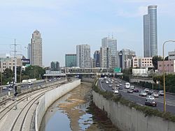
Ayalon Highway (Hebrew: נתיבי איילון, pronounced: "Netivei Ayalon", lit. "Ayalon Routes") is a highway system in the Tel Aviv Metropolitan Area. The main road goes through Tel Aviv and is called Highway 20. The road starts in HaMa'apilim Interchange near the cities Kfar Shmaryahu, Herzliya, Ramat HaSharon. It ends at Holot Interchange in Gan Sorek. It goes through the cities of Bat Yam, Holon and Rishon LeZion. It meets Highway 4. A railway line runs along the road with a major train station inside the gates road. In central Tel Aviv, the road passes a canal of the Ayalon River.
Images for kids

All content from Kiddle encyclopedia articles (including the article images and facts) can be freely used under Attribution-ShareAlike license, unless stated otherwise. Cite this article:
Ayalon Highway Facts for Kids. Kiddle Encyclopedia.


