Atacama Region facts for kids
- This article is about the Atacama Region; for the desert, see Atacama Desert.
Quick facts for kids Atacama Region (III Región de Atacama) |
|||
| Region of Chile | |||
|
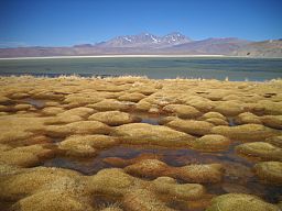
Laguna Santa Rosa, Atacama
|
|||
|
|||
| Country | |||
|---|---|---|---|
| Provinces | Chañaral, Copiapó, Huasco | ||
| Capital | Copiapó | ||
| - coordinates | 27°22′S 70°19′W / 27.367°S 70.317°W | ||
| Highest point | Nevado Ojos del Salado | ||
| - elevation | 6,893 m (22,615 ft) | ||
| - coordinates | 27°06′34″S 68°32′24″W / 27.10944°S 68.54000°W | ||
| Lowest point | Sea level | ||
| - elevation | 0 m (0 ft) | ||
| Area | 75,176.2 km² (29,026 sq mi) | ||
| Population | 312,486 (2015) | ||
| Density | 4 /km² (10 /sq mi) | ||
| Intendant | Miguel Vargas Correa | ||
| ISO 3166-2 | CL-AT | ||
The III Atacama Region Region (Spanish: III Región de Atacama) is one of Chile's 15 first order administrative divisions. The southern portion of the Atacama Desert is in the region; the rest of the desert is in the other regions to the north (Norte Grande natural region).
The capital of the region is the city of Copiapó; it is at 806 km (501 mi) north of Santiago, the capital of country.
History
From 1843, Atacama was a province of Chile but in 1974, with the creation of the Regions of Chile, it became one of those regions.
Geography
The Atacama region borders the Tarapacá region to the north, Argentina (provinces of Catamarca, La Rioja and San Juan), on the east, the Coquimbo region on the south and the Pacific Ocean on the west.
 |
Tarapacá region | Catamarca province (Argentina) |  |
|
| Pacific Ocean | La Rioja province (Argentina) | |||
| Coquimbo region | San Juan province (Argentina) |
The highest mountains of the region are: Nevados Ojos del Salado, 6,893 m (22,615 ft) high, and Nevado Tres Cruces, 6,748 m (22,139 ft) high; they are in the Andes, in the border with Argentina.
Population
As of 2015[update], there were (estimated) 312,486 persons living in the region, for a population density of 4.2 inhabitants/km².
The largest city in the region is its capital, Copiapó, with 125,983 inhabitants (2002 census).
Administration
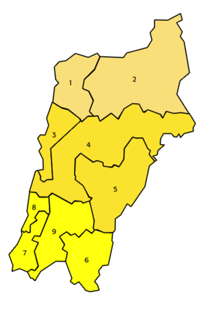
The Atacama region is divided in three provinces: Chañaral, Copiapó and Huasco.
| Provinces | Capital | Code | Comunas | Area (km²) |
Population 2002 |
|---|---|---|---|---|---|
| Copiapó (031) |
Copiapó | 03101 | 4 Copiapó | 16,681.3 | 129,091 |
| 03102 | 3 Caldera | 4,666.6 | 13,734 | ||
| 03103 | 5 Tierra Amarilla | 11,190.6 | 12,888 | ||
| Total of the Copiapó province | 32,538.5 | 155,713 | |||
| Chañaral (032) |
Chañaral | 03201 | 1 Chañaral | 5,772.4 | 13,543 |
| 03202 | 2 Diego de Almagro | 18,663.8 | 18,589 | ||
| Total of the Chañaral province | 24,436.2 | 32,132 | |||
| Huasco (033) |
Vallenar | 03301 | 9 Vallenar | 7,083.7 | 48,040 |
| 03302 | 6 Alto del Carmen | 5,938.7 | 4,840 | ||
| 03303 | 7 Freirina | 3,577.7 | 5,666 | ||
| 03304 | 8 Huasco | 1,601.4 | 7,945 | ||
| Total of the Huasco province | 18,201.5 | 66,491 | |||
| Total of the region | 75,176.2 | 254,336 | |||
Related pages
| Regions of Chile | |
|---|---|
| Arica y Parinacota | Tarapacá | Antofagasta | Atacama | Coquimbo | Valparaíso | O'Higgins | Maule | Bío Bío | La Araucanía | Los Ríos | Los Lagos | Aysén | Magallanes y la Antártica Chilena | RM Santiago | |
Images for kids
See also
 In Spanish: Región de Atacama para niños


