Artesa de Segre facts for kids
Quick facts for kids
Artesa de Segre
|
|
|---|---|
|
Municipality
|
|

Artesa de Segre
|
|
| Country | |
| Community | |
| Province | Lleida |
| Comarca | Noguera |
| Area | |
| • Total | 175.9 km2 (67.9 sq mi) |
| Elevation | 394 m (1,293 ft) |
| Population
(2018)
|
|
| • Total | 3,447 |
| • Density | 19.596/km2 (50.754/sq mi) |
| Demonym(s) | Artesenc, artesenca |
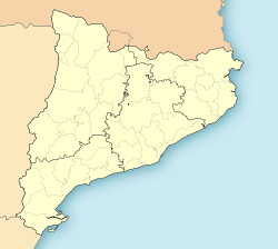
Artesa de Segre (Catalan pronunciation: [aɾˈteza ðe ˈseɣɾe]) is a municipality in the comarca of the Noguera in Catalonia, Spain. It is situated in the valley of the Segre river, between Ponts and Balaguer. The municipal territory extends as far as the confluence of the Segre with the Boix. The Urgell canal runs through the municipality to the south of the Segre. The municipality is served by the C-1313 road between Balaguer and Ponts, and is linked to Agramunt by the L-302 road.
Demography
| 1900 | 1930 | 1950 | 1970 | 1986 | 2007 |
|---|---|---|---|---|---|
| 4712 | 4901 | 4600 | 3541 | 3250 | 3737 |
Subdivisions
The municipality of Artesa de Segre include nineteen outlying villages: populations are given as of 2005.
- Alentorn (143)
- Anya (32)
- Baldomar (127)
- La Clua (19)
- Colldelrat (33)
- Collfred (29)
- Colònia la Fàbrica
- Comiols (7)
- Folquer (4)
- Montargull (57)
- Montmagastre (22)
- El Pont d'Alentorn (31)
- Sant Marc del Batlliu (20)
- Seró (93)
- Tudela de Segre (108)
- La Vall d'Ariet
- Vall-Llebrera(35)
- Vall-Llebrerola
- La Vedrenya (15)
- Vernet (42)
- Vilves (58)
See also
 In Spanish: Artesa de Segre para niños

All content from Kiddle encyclopedia articles (including the article images and facts) can be freely used under Attribution-ShareAlike license, unless stated otherwise. Cite this article:
Artesa de Segre Facts for Kids. Kiddle Encyclopedia.


