Arley, Alabama facts for kids
Quick facts for kids
Arley, Alabama
|
|
|---|---|

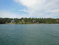
Homes on Lewis Smith Lake near Arley
|
|

Location of Arley in Winston County, Alabama.
|
|
| Country | United States |
| State | Alabama |
| County | Winston |
| Area | |
| • Total | 3.77 sq mi (9.77 km2) |
| • Land | 3.76 sq mi (9.74 km2) |
| • Water | 0.01 sq mi (0.03 km2) |
| Elevation | 778 ft (237 m) |
| Population
(2020)
|
|
| • Total | 330 |
| • Density | 87.74/sq mi (33.88/km2) |
| Time zone | UTC-6 (Central (CST)) |
| • Summer (DST) | UTC-5 (CDT) |
| ZIP code |
35540-35541
|
| Area codes | 205, 659, 256 |
| FIPS code | 01-02500 |
| GNIS feature ID | 0159081 |
Arley is a town in Winston County, Alabama, United States. It incorporated on December 18, 1965. At the 2020 census the population was 330, down from 357 in 2010.
Contents
Geography
Arley is located at 34°4′53″N 87°12′39″W / 34.08139°N 87.21083°W (34.081499, -87.210768), partially inside William B. Bankhead National Forest. The town has a total land area of 3.76 square miles (9.7 km2). Bounded by Lewis Smith Lake and the nearby town of Addison, Arley's terrain is forested and rural with rolling hills.
Climate
The climate in this area is characterized by hot, humid summers and generally mild to cool winters. According to the Köppen Climate Classification system, Arley has a humid subtropical climate, abbreviated "Cfa" on climate maps.
Demographics
Town of Arley
| Historical population | |||
|---|---|---|---|
| Census | Pop. | %± | |
| 1970 | 164 | — | |
| 1980 | 276 | 68.3% | |
| 1990 | 338 | 22.5% | |
| 2000 | 290 | −14.2% | |
| 2010 | 357 | 23.1% | |
| 2020 | 330 | −7.6% | |
| U.S. Decennial Census | |||
Arley was incorporated in 1965 and first appeared as a town on the 1970 census. The area it is located in was also named Arley, and the former precinct existed from 1920 until its dissolution in 1960. See below.
Historic Demographics
| Census Year |
Population & Racial Majority |
State Place Rank |
County Place Rank |
White (White, Non- Hispanic 1980- |
Hispanic (1980- |
Native American |
Asian | Pacific Islander |
Other | 2 or More Races (2000- |
|---|---|---|---|---|---|---|---|---|---|---|
| 1970 | 164 (-) | 406th (-) | 5th (-) | |||||||
| 1980 | 276 ↑ | 386th ↑ | 5th X | |||||||
| 1990 | 338 ↑ | 377th ↑ | 5th X | |||||||
| 2000 | 290 ↓ | 414th ↓ | 5th X | 284 (-) 97.9% | 4 (-) 1.4% | 2 (-) 0.7% | ||||
| 2010 | 357 ↑ | 433rd ↓ | 5th X | 336 ↑ 94.1% | 5 ↑ 1.4% | 2 (-) 0.6% | 1 (-) 0.3% | 1 (-) 0.3% | 1 (-) 0.3% | 15 ↑ 4.2% |
Arley Precinct (1920-1950)
| Historical population | |||
|---|---|---|---|
| Census | Pop. | %± | |
| 1920 | 1,030 | — | |
| 1930 | 1,126 | 9.3% | |
| 1940 | 1,524 | 35.3% | |
| 1950 | 1,286 | −15.6% | |
| U.S. Decennial Census | |||
Arley Precinct (Winston County 5th precinct) first appeared on the 1920 U.S. Census. It had been previously named Dismal from 1890-1910. In 1960, the precinct was merged as part of a larger reorganization of counties into the census division of Addison.
Education
Public K-12 education in Arley is provided by Winston County Schools. Meek Elementary School (grades K-6) and Meek High School (grades 7-12) serve the town. Arley has a branch of the Carl Elliott Regional Library.
See also
 In Spanish: Arley (Alabama) para niños

