Ardmore, Tennessee facts for kids
Quick facts for kids
Ardmore, Tennessee
|
|
|---|---|

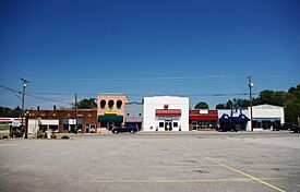
Buildings along Main Street (SR 7)
|
|

Location in Giles County, Tennessee
|
|
| Country | United States |
| State | Tennessee |
| Counties | Giles, Lincoln |
| Founded | 1911 |
| Incorporated | 1949 |
| Area | |
| • Total | 4.705 sq mi (12.186 km2) |
| • Land | 4.698 sq mi (12.167 km2) |
| • Water | 0.007 sq mi (0.018 km2) |
| Elevation | 886 ft (270 m) |
| Population
(2020)
|
|
| • Total | 1,217 |
| • Estimate
(2022)
|
1,219 |
| • Density | 258.66/sq mi (99.87/km2) |
| Time zone | UTC−6 (Central (CST)) |
| • Summer (DST) | UTC−5 (CDT) |
| ZIP Code |
38449
|
| Area code(s) | 931 |
| FIPS code | 47-01640 |
| GNIS feature ID | 1304866 |
Ardmore is a city in Giles and Lincoln counties, Tennessee, United States. The population was 1,217 at the 2020 census. Ardmore is the site of a Tennessee Department of Tourist Development Welcome Center. It borders its sister city, Ardmore, Alabama.
Contents
History
Ardmore began in 1911 as a railroad stop named "Austin" after a store owner, Alex Austin, who served construction crews working on the nearby L&N Railroad (now CSX) line that would connect Nashville, Tennessee, and Decatur, Alabama. When the L&N opened a depot in 1914, it changed the town's name to "Ardmore." The name was likely inspired by Ardmore, Pennsylvania. Ardmore, Tennessee, incorporated in 1949.
Geography
Ardmore is located at 34°59′31″N 86°50′48″W / 34.99194°N 86.84667°W (34.9920292, -86.8466694). The city is concentrated along Tennessee State Route 7 (Main Street), which runs congruent with Alabama State Route 53 along the state line before veering northwestward to its intersection with Interstate 65 and U.S. Route 31 in the western part of the city. US 31 connects Ardmore with Elkton, Tennessee, which lies to the northwest, and Tennessee State Route 110 connects Ardmore with Fayetteville to the northeast. Ardmore is the southern terminus of U.S. Bicycle Route 23.
According to the United States Census Bureau, the city has a total area of 4.705 square miles (12.19 km2), of which 4.698 square miles (12.17 km2) is land and 0.007 square miles (0.018 km2), is water. Ardmore's business district is located primarily in Giles County, though the eastern parts of the city are located in Lincoln County. The Elk River passes northwest of Ardmore.
Climate
| Climate data for Ardmore, Tennessee, 1991–2020 normals, extremes 2008–2020 | |||||||||||||
|---|---|---|---|---|---|---|---|---|---|---|---|---|---|
| Month | Jan | Feb | Mar | Apr | May | Jun | Jul | Aug | Sep | Oct | Nov | Dec | Year |
| Record high °F (°C) | 76 (24) |
81 (27) |
85 (29) |
89 (32) |
96 (36) |
102 (39) |
102 (39) |
100 (38) |
99 (37) |
96 (36) |
88 (31) |
78 (26) |
102 (39) |
| Mean daily maximum °F (°C) | 51.9 (11.1) |
57.4 (14.1) |
66.1 (18.9) |
75.0 (23.9) |
81.5 (27.5) |
87.7 (30.9) |
90.8 (32.7) |
90.5 (32.5) |
85.3 (29.6) |
76.3 (24.6) |
64.8 (18.2) |
55.1 (12.8) |
73.5 (23.1) |
| Daily mean °F (°C) | 40.9 (4.9) |
45.1 (7.3) |
53.1 (11.7) |
61.7 (16.5) |
70.0 (21.1) |
77.2 (25.1) |
80.5 (26.9) |
79.3 (26.3) |
73.5 (23.1) |
62.9 (17.2) |
51.8 (11.0) |
43.9 (6.6) |
61.7 (16.5) |
| Mean daily minimum °F (°C) | 29.9 (−1.2) |
32.7 (0.4) |
40.0 (4.4) |
48.3 (9.1) |
58.4 (14.7) |
66.7 (19.3) |
70.1 (21.2) |
68.0 (20.0) |
61.7 (16.5) |
49.4 (9.7) |
38.7 (3.7) |
32.7 (0.4) |
49.7 (9.9) |
| Record low °F (°C) | 3 (−16) |
6 (−14) |
16 (−9) |
29 (−2) |
38 (3) |
51 (11) |
55 (13) |
56 (13) |
45 (7) |
27 (−3) |
17 (−8) |
12 (−11) |
3 (−16) |
| Average precipitation inches (mm) | 4.77 (121) |
5.39 (137) |
5.44 (138) |
5.10 (130) |
3.82 (97) |
4.90 (124) |
4.92 (125) |
3.57 (91) |
3.54 (90) |
3.22 (82) |
4.01 (102) |
7.00 (178) |
55.68 (1,415) |
| Source 1: NOAA | |||||||||||||
| Source 2: XMACIS2 | |||||||||||||
Demographics
| Historical population | |||
|---|---|---|---|
| Census | Pop. | %± | |
| 1950 | 157 | — | |
| 1960 | 195 | 24.2% | |
| 1970 | 601 | 208.2% | |
| 1980 | 835 | 38.9% | |
| 1990 | 866 | 3.7% | |
| 2000 | 1,082 | 24.9% | |
| 2010 | 1,213 | 12.1% | |
| 2020 | 1,217 | 0.3% | |
| 2022 (est.) | 1,219 | 0.5% | |
| U.S. Decennial Census 2020 Census |
|||
2020 census
| Race | Number | Percentage |
|---|---|---|
| White (non-Hispanic) | 1,079 | 88.66% |
| Black or African American (non-Hispanic) | 35 | 2.88% |
| Native American | 1 | 0.08% |
| Asian | 8 | 0.66% |
| Pacific Islander | 1 | 0.01% |
| Other/Mixed | 57 | 4.68% |
| Hispanic or Latino | 36 | 2.96% |
As of the 2020 census, there were 1,217 people, 514 households, and 330 families residing in the city. There were 547 housing units.
See also
 In Spanish: Ardmore (Tennessee) para niños

