Archer, Nebraska facts for kids
Quick facts for kids
Archer, Nebraska
|
|
|---|---|
 |
|
| Country | United States |
| State | Nebraska |
| County | Merrick |
| Area | |
| • Total | 1.00 sq mi (2.60 km2) |
| • Land | 1.00 sq mi (2.60 km2) |
| • Water | 0.00 sq mi (0.00 km2) |
| Elevation | 1,745 ft (532 m) |
| Population
(2020)
|
|
| • Total | 68 |
| • Density | 67.86/sq mi (26.19/km2) |
| Time zone | UTC-6 (Central (CST)) |
| • Summer (DST) | UTC-5 (CDT) |
| ZIP code |
68816
|
| FIPS code | 31-01920 |
| GNIS feature ID | 2583872 |
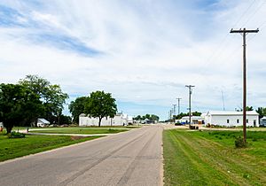
Archer is an unincorporated rural small town and census-designated place (CDP) in Merrick County, Nebraska, United States. As of the 2020 census the population was 68. The Archer post office carries the ZIP Code 68816.
Contents
History
The community is named for Robert T. Archer. A post office was established at Archer in 1887, and it is still in use.
Geography
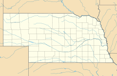
Archer is in northwestern Merrick County, lying along local roads south of Nebraska Highway 92 and about 10 miles (16 km) northwest of Central City, the county seat. There is a credit union, a grainery and other businesses and services, as well as homes, in the community.
According to the U.S. Census Bureau, the Archer CDP has an area of 1.00 square mile (2.59 km2), all of it recorded as land. Prairie Creek passes through the south side of the community, flowing northeast to join the Platte River between Silver Creek and Columbus.
Demographics
| Historical population | |||
|---|---|---|---|
| Census | Pop. | %± | |
| 2010 | 81 | — | |
| 2020 | 68 | −16.0% | |
| U.S. Decennial Census | |||
See also
 In Spanish: Archer (Nebraska) para niños


