Anthony Peak facts for kids
Quick facts for kids Anthony Peak |
|
|---|---|

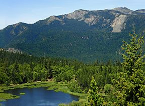
Howard Lake at the base of Anthony Peak
(shown in background) |
|
| Highest point | |
| Elevation | 6,958 ft (2,121 m) NAVD 88 |
| Prominence | 1,514 ft (461 m) |
| Isolation | 9.37 mi (15.08 km) to Black Butte (Glenn Co.) |
| Parent peak | Mount Linn |
| Listing | California county high points: 31st |
| Geography | |
| Location | Mendocino National Forest |
| Country | United States |
| State | California |
| County | Mendocino |
| Parent range | Northern Coast Ranges |
| Topo map | USGS Mendocino Pass (#101569) |
| Biome | Montane Douglas fir forest |
| Geology | |
| Formed by | Accretion |
| Orogeny | Franciscan Assemblage |
| Age of rock | Cenomanian (~95 Ma ago) |
| Mountain type | Fold mountain |
| Type of rock | Ophiolite |
| Climbing | |
| Easiest route | Road hike (YDS Class 1) |
| Access | Mendocino Pass Road → (a/k/a FH-7 or County Road 338) Forest Road M4 → (a/k/a FS-23N69) Service Road FS-23N60 |
Anthony Peak is a mountain located in the Mendocino National Forest north of Mendocino Pass and is part of the Northern Coast Ranges of Mendocino County, California, approximately 16 miles (26 km) NE of Covelo. The summit is the highest point in Mendocino County, and averages 61.8 inches at peak snow pack depth annually.
The rare endemic wildflower known as Anthony Peak lupine (Lupinus antoninus) was named for this peak.
The peak was probably named for James Anthony, who owned a farm in the Round Valley district in 1874.

All content from Kiddle encyclopedia articles (including the article images and facts) can be freely used under Attribution-ShareAlike license, unless stated otherwise. Cite this article:
Anthony Peak Facts for Kids. Kiddle Encyclopedia.


