Annagh Hill facts for kids
Quick facts for kids Annagh Hill |
|
|---|---|
| An tEannach Meaning Marsh or Bog | |

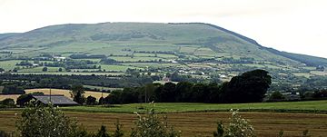
Annagh Hill, from the southeast
|
|
| Highest point | |
| Elevation | 454 m (1,490 ft) |
| Prominence | 231 m (758 ft) |
| Listing | Marilyn |
| Geography | |
| Location | Wexford, Ireland |
| Parent range | Wicklow Mountains |
| OSI/OSNI grid | T100680 |
| Topo map | OSi Discovery 62 |
Annagh Hill (An tEannach) meaning marsh or bog in Gaelic. Located in the north of county Wexford.
Geography
Annagh Hill is separated from Croghan Mountain to the north by the "Wicklow Gap", not to be confused with the Wicklow Gap in County Wicklow. Except for the southeastern face (see photo) it is covered in coniferous forestry.
It overlooks the villages of Monaseed and Hollyfort to the south, across the valley of the Blackwater stream

All content from Kiddle encyclopedia articles (including the article images and facts) can be freely used under Attribution-ShareAlike license, unless stated otherwise. Cite this article:
Annagh Hill Facts for Kids. Kiddle Encyclopedia.

