Angora, Nebraska facts for kids
"Antelope Hill" redirects here. For the hill in Arizona, see Antelope Hill, Arizona. For the white nationalist book publisher, see Antelope Hill Publishing.
Quick facts for kids
Angora, Nebraska
|
|
|---|---|

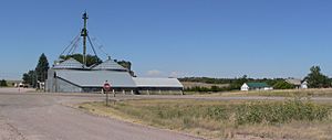
Angora, seen from the east across U.S. Highway 385
|
|
| Country | United States |
| State | Nebraska |
| County | Morrill |
| Elevation | 4,265 ft (1,300 m) |
| Time zone | UTC-7 (Mountain (MST)) |
| • Summer (DST) | UTC-6 (MDT) |
| ZIP code |
69331
|
| Area code(s) | 308 |
Angora (also Antelope Hill) is an unincorporated community in northern Morrill County, Nebraska, United States. It lies along U.S. Route 385, north of the city of Bridgeport, the county seat of Morrill County. The community was established in 1900 by the Chicago, Burlington, and Quincy Railroad; it was named for the Turkish city of Ankara, which was then known as Angora. The Angora post office was established in 1901, and it remains open with the assigned ZIP code of 69331.
Climate
According to the Köppen climate classification, Angora has a semiarid climate, BSk on climate maps.

All content from Kiddle encyclopedia articles (including the article images and facts) can be freely used under Attribution-ShareAlike license, unless stated otherwise. Cite this article:
Angora, Nebraska Facts for Kids. Kiddle Encyclopedia.


