Angier, North Carolina facts for kids
Quick facts for kids
Angier, North Carolina
|
||
|---|---|---|
 |
||
|
||
| Motto(s):
"Town of Crepe Myrtles"
|
||

Location in North Carolina
|
||
| Country | United States | |
| State | North Carolina | |
| Counties | Harnett, Wake | |
| Area | ||
| • Total | 3.86 sq mi (10.00 km2) | |
| • Land | 3.83 sq mi (9.91 km2) | |
| • Water | 0.03 sq mi (0.09 km2) | |
| Elevation | 318 ft (97 m) | |
| Population
(2020)
|
||
| • Total | 5,265 | |
| • Density | 1,376.47/sq mi (531.39/km2) | |
| Time zone | UTC-5 (EST) | |
| • Summer (DST) | UTC-4 (EDT) | |
| ZIP code |
27501
|
|
| Area code(s) | 919 | |
| FIPS code | 37-01400 | |
| GNIS feature ID | 2405152 | |
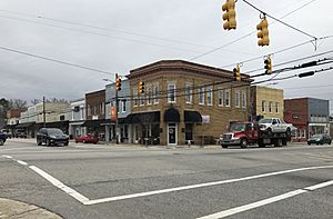
Angier (/ˈændʒɜːr/ AN-jur) is a town in the Black River Township of Harnett County, North Carolina, United States. The population was 4,350 at the 2010 census and estimated as of 2018 to be 5,253. Angier is a part of the greater Raleigh–Durham–Cary Combined Statistical Area (CSA) as defined by the United States Census Bureau.
History
The town was founded in the late 1880s and named for the Angier family of Durham, NC. The Williams Grove School was listed on the National Register of Historic Places in 1995.
Geography
Angier is located in northern Harnett County. A small portion of the town is in Wake County to the north. North Carolina Highway 55 (Raleigh Street) passes through the center of town, leading north 7 miles (11 km) to Fuquay-Varina and south 14 miles (23 km) to Erwin. Raleigh, the state capital, is 22 miles (35 km) to the north via NC-55 and U.S. Route 401. North Carolina Highway 210 (Depot Street) crosses Highway 55 in the center of Angier, leading east 10 miles (16 km) to Interstate 40 and southwest 9 miles (14 km) to Lillington, the Harnett county seat.
According to the United States Census Bureau, the town of Angier has a total area of 2.9 square miles (7.6 km2), of which 2.9 square miles (7.5 km2) are land and 0.04 square miles (0.1 km2), or 1.18%, are water.
Demographics
| Historical population | |||
|---|---|---|---|
| Census | Pop. | %± | |
| 1910 | 221 | — | |
| 1920 | 374 | 69.2% | |
| 1930 | 760 | 103.2% | |
| 1940 | 1,028 | 35.3% | |
| 1950 | 1,182 | 15.0% | |
| 1960 | 1,249 | 5.7% | |
| 1970 | 1,431 | 14.6% | |
| 1980 | 1,709 | 19.4% | |
| 1990 | 2,235 | 30.8% | |
| 2000 | 3,419 | 53.0% | |
| 2010 | 4,350 | 27.2% | |
| 2020 | 5,265 | 21.0% | |
| 2023 (est.) | 7,283 | 67.4% | |
| U.S. Decennial Census | |||
2020 census
| Race | Number | Percentage |
|---|---|---|
| White (non-Hispanic) | 2,845 | 54.04% |
| Black or African American (non-Hispanic) | 1,005 | 19.09% |
| Native American | 10 | 0.19% |
| Asian | 39 | 0.74% |
| Other/Mixed | 230 | 4.37% |
| Hispanic or Latino | 1,136 | 21.58% |
As of the 2020 United States census, there were 5,265 people, 2,056 households, and 1,429 families residing in the town.
Education
- Carolina Charter Academy
- McGee's Crossroads Elementary School
- Angier Elementary School
- North Harnett Primary School
- Harnett Central Middle School
- Harnett Central High School
Culture
Angier annually hosts the "Crepe Myrtle Festival", which attracts approximately 20,000 visitors. The town calls itself "The Town of Crepe Myrtles". Each summer Angier draws a crowd of motorcyclists and bike enthusiasts from across the region to downtown Angier to enjoy the sights, sounds and tastes of its annual Bike Fest event. The family-friendly event features live music, a bike show, a poker-run fund-raiser, exhibits and fun for people of all ages.
Angier lies along the "Art Road and Farm Trail" through Bladen, Cumberland, Harnett, Johnston and Robeson counties.
Notable persons
- Franklin Dupree, federal judge
- Rhoda Griffis, actress
- Stephanie Patrick, YouTuber
See also
 In Spanish: Angier para niños


