Ampara District facts for kids
Quick facts for kids
Ampara District
அம்பாறை மாவட்டம்
අමිපාර දිස්ත්රික්කය |
|
|---|---|

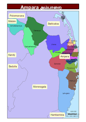
Administrative units of Ampara District in 2006
|
|
| Country | Sri Lanka |
| Province | Eastern |
| Created | April 1961 |
| Capital | Ampara |
| DS Division |
List
Addalaichchenai
Akkaraipattu Alayadivembu Ampara Damana Dehiattakandiya Irakkamam Kalmunai (Muslim) Kalmunai (Tamil) Karaitivu Lahugala Maha Oya Navithanveli Nintavur Padiyathalawa Pottuvil Sainthamarathu Samanthurai Thirukkovil Uhana |
| Area | |
| • Total | 4,415 km2 (1,705 sq mi) |
| • Land | 4,222 km2 (1,630 sq mi) |
| • Water | 193 km2 (75 sq mi) 4.37% |
| Area rank | 4th (6.73% of total area) |
| Population
(2012 census)
|
|
| • Total | 648,057 |
| • Rank | 14th (3.20% of total pop.) |
| • Density | 146.785/km2 (380.17/sq mi) |
| Time zone | UTC+05:30 (Sri Lanka) |
| Post Codes |
32000-32999
|
| Telephone Codes | 063, 067 |
| ISO 3166 code | LK-52 |
| Vehicle registration | EP |
| Official Languages | Tamil, Sinhala |
Ampara District (Tamil: அம்பாறை மாவட்டம் Ampāṟai Māvaṭṭam; Sinhala: අමිපාර දිස්ත්රික්කය) is one of the 25 districts of Sri Lanka. Districts are the second-level administrative divisions of the country. Ampara District is part of the Eastern Province. The capital of the district is the town of Ampara.
The district was separated from the southern part of Batticaloa District in April 1961.
Geography
The Ampara District is in the southeast part of Sri Lanka in the Eastern Province. It has an area of 4,415 square kilometres (1,705 sq mi).
See also
 In Spanish: Distrito de Ampara para niños

All content from Kiddle encyclopedia articles (including the article images and facts) can be freely used under Attribution-ShareAlike license, unless stated otherwise. Cite this article:
Ampara District Facts for Kids. Kiddle Encyclopedia.
