Amalia, New Mexico facts for kids
Quick facts for kids
Amalia, New Mexico
|
|
|---|---|

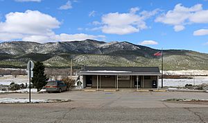
The post office in Amalia
|
|
| Country | United States |
| States | New Mexico |
| County | Taos |
| Elevation | 8,147 ft (2,483 m) |
| Time zone | UTC−7 (Mountain (MST)) |
| • Summer (DST) | UTC−6 (MDT) |
| ZIP code |
87512
|
| Area code(s) | 575 |
| GNIS feature ID | 902162 |
Amalia is an unincorporated community in Taos County, New Mexico, United States.
Description
Amalia is located near the Colorado border, on New Mexico State Road 196.
Amalia has a post office, with the ZIP code 87512. The 87512 ZIP Code Tabulation Area had a population of 230 at the 2000 census.
History
Amalia was formerly known as Pina, perhaps a modification of the Spanish word for 'pine'. A post office was established in 1900; in 1919, the settlement was renamed after the given name for unknown reasons.
In summer of 2018, at a remote site with a small camping trailer within a surrounding wall of car tires, five adults, 11 hungry children (ages 1 to 15), and later a dead child, were found. Court documents stated the children had been trained for shootings at schools. Federal terrorism, kidnapping, and firearms charges were brought against the five adults in March 2019; in 2024, one was sentenced to 15 years in prison and the other four to a life sentence under a federal kidnapping statute minimum sentencing dating to the Lindbergh kidnapping.


