Alma, South Australia facts for kids
Quick facts for kids AlmaSouth Australia |
|||||||||||||||
|---|---|---|---|---|---|---|---|---|---|---|---|---|---|---|---|

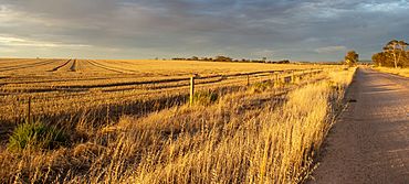
Farmland in Alma
|
|||||||||||||||
| Postcode(s) | 5401 | ||||||||||||||
| Time zone | ACST (UTC+9:30) | ||||||||||||||
| • Summer (DST) | ACDT (UTC+10:30) | ||||||||||||||
| Location | 7 km (4 mi) E of Owen | ||||||||||||||
| LGA(s) |
|
||||||||||||||
| State electorate(s) | Goyder | ||||||||||||||
| Federal Division(s) | Grey | ||||||||||||||
|
|||||||||||||||
Alma is a small town in South Australia halfway between the Wakefield River, to the north, and River Light to the south. Alma, Alma South and Alma Plains were named for the cadastral Hundred of Alma in which they lie, which was in turn named after the Battle of the Alma, the site of an allied victory in the Crimean War.
Alma is located approximately 74 km from Adelaide and covers an area of 102.786 km2. It has a recorded population of 75 residents.
Churches
There are no longer any churches operating in the Alma area. There are or have been churches and cemeteries associated with several denominations:
- Church of Christ (1862–1938), corner of Branson Road and Alma South Road
- Congregational Church at Alma Plains (1865–1928), corner of Almond Tree Road and Freebairn Road
- Replaced by new building in Alma township (corner of Alma Road and Almond Tree Road), 1928–1972
- Primitive Methodist Church (corner of Owen Road and McKenzie Road) original building 1866 replaced 1878
Notable people
Notable from or who have lived in Alma include:
- Robert Caldwell, farmer and politician
- James Gilbert Woolcock, metallurgist, mining consultant, mining engineer

All content from Kiddle encyclopedia articles (including the article images and facts) can be freely used under Attribution-ShareAlike license, unless stated otherwise. Cite this article:
Alma, South Australia Facts for Kids. Kiddle Encyclopedia.

