
Allen, Michigan facts for kids
Quick facts for kids
Allen, Michigan
|
|
|---|---|
|
Village
|
|
| Village of Allen | |
.jpg)
Looking east along W. Chicago Road (US 12)
|
|
| Nickname(s):
"Antique Capital of Michigan"
|
|

Location within Hillsdale County
|
|

Allen, Michigan
Location in Michigan

Allen, Michigan
Location in the United States
|
|
| Country | United States |
| State | Michigan |
| County | Hillsdale |
| Township | Allen |
| Settled | 1827 |
| Platted | 1868 |
| Incorporated | 1950 |
| Government | |
| • Type | Village council |
| Area | |
| • Total | 0.174 sq mi (0.451 km2) |
| • Land | 0.174 sq mi (0.451 km2) |
| • Water | 0.00 sq mi (0.00 km2) |
| Elevation | 1,076 ft (328 m) |
| Population
(2020)
|
|
| • Total | 201 |
| • Density | 1,155.17/sq mi (446.62/km2) |
| Time zone | UTC-5 (Eastern (EST)) |
| • Summer (DST) | UTC-4 (EDT) |
| ZIP code(s) |
49227
|
| Area code(s) | 517 |
| FIPS code | 26-01300 |
| GNIS feature ID | 2397933 |
Allen is a village in Hillsdale County in the U.S. state of Michigan. The population was 201 at the 2020 census.
The village is within Allen Township at the junction of U.S. Route 12 and M-49. With a total land area of only 0.174 square miles (0.451 km2), Allen is the fourth smallest village by land area in the state of Michigan and the fifth smallest municipality overall after Ahmeek, Copper City, Novi Township, and Eagle.
Contents
History
The community was first settled by War of 1812 veteran Captain Moses Allen and his family in 1827. A post office under the name Sylvanus opened on July 13, 1830. It closed briefly from September 5, 1834, to September 9, 1835. The name of the office was changed to Allen in honor of Moses Allen on August 17, 1868. The community was thriving and was platted that same year, and Allen received a railway depot along the Lake Shore and Michigan Southern Railway. In 1950, Allen incorporated as a village.
Geography
According to the U.S. Census Bureau, the village has a total area of 0.174 square miles (0.451 km2), all land.
Major highways
 US 12 (W. Chicago Street) runs east–west through the center of the village.
 M-49 (N. Railroad Street) enters the village from the north and briefly runs concurrently with US 12.
Demographics
| Historical population | |||
|---|---|---|---|
| Census | Pop. | %± | |
| 1960 | 325 | — | |
| 1970 | 385 | 18.5% | |
| 1980 | 266 | −30.9% | |
| 1990 | 201 | −24.4% | |
| 2000 | 225 | 11.9% | |
| 2010 | 191 | −15.1% | |
| 2020 | 201 | 5.2% | |
| U.S. Decennial Census | |||
2010 census
As of the census of 2010, there were 191 people, 80 households, and 51 families residing in the village. The population density was 1,193.8 inhabitants per square mile (460.9/km2). There were 94 housing units at an average density of 587.5 per square mile (226.8/km2). The racial makeup of the village was 97.9% White, 1.0% Asian, and 1.0% from two or more races.
There were 80 households, of which 23.8% had children under the age of 18 living with them, 56.3% were married couples living together, 6.3% had a female householder with no husband present, 1.3% had a male householder with no wife present, and 36.3% were non-families. 25.0% of all households were made up of individuals, and 18.8% had someone living alone who was 65 years of age or older. The average household size was 2.39 and the average family size was 2.94.
The median age in the village was 45.8 years. 19.4% of residents were under the age of 18; 7.8% were between the ages of 18 and 24; 22.1% were from 25 to 44; 26.7% were from 45 to 64; and 24.1% were 65 years of age or older. The gender makeup of the village was 49.7% male and 50.3% female.
Education
The village is served entirely by the Quincy Community School District to the west in the village of Quincy in Branch County.
Notable people
- Ed Donnelly, professional Major League Baseball player, born in Allen
- Charles Edward St. John, astronomer and college professor, born in Allen
Images for kids
-

U.S. Post Office in Allen -
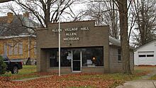
Allen Village Hall -
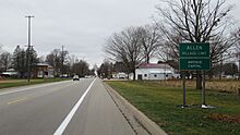
Signage westward along US 12 / M-49 -

Captain Moses Allen historic marker


.jpg)
See also
 In Spanish: Allen (Míchigan) para niños
