Allegheny Mountain (Pennsylvania) facts for kids
Quick facts for kids Allegheny Mountain |
|
|---|---|
| Allegheny Ridge | |

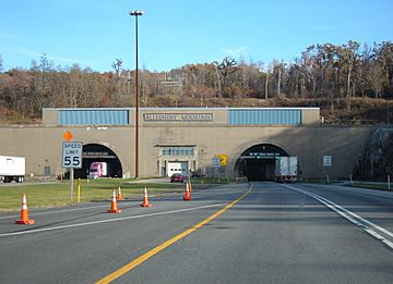
Allegheny Mountain Tunnel on the Pennsylvania Turnpike
|
|
| Highest point | |
| Peak | Grandview Summit (Eastern Continental Divide) |
| Elevation | 3,010.3 ft (917.5 m) |
| Geography | |
| Country | United States |
| Parent range | Ridge-and-Valley Appalachians of the Allegheny Mountains |
| Geology | |
| Orogeny | Alleghenian orogeny |
| Type of rock | Carboniferous |
Allegheny Mountain is a stratigraphic ridge that extends northeast to southwest from south of Blue Knob (Pennsylvania) to a saddle point at the Savage Mountain anticline. It merges with Negro Mountain just north of the Cambria County line where the Berlin-Salisbury basin expires [1].
- Eastern Continental Divide (ECD)
- The ECD enters Allegheny Mountain south of Fraziers Pass and follows the Allegheny Backbone [2] southwest where it leaves the escarpment toward the saddle point to the southeast between headwaters of Flaugherty and Wills Creeks, at which the ECD enters the Savage Mountain anticline.[3]
| wikiarticle | west valley | summit or other point | east valley |
|---|---|---|---|
| Northern terminus | |||
| Fraziers Pass | 2,180 feet (660 m) (Stonycreek River) | 3,010.3 feet (917.5 m)40°3′29″N 78°45′29″W / 40.05806°N 78.75806°W (Grandview Summit) | 1,100 feet (340 m) (Juniata River) |
| US Route 30 | 2,580 feet (790 m) (Breastwork Run) | ||
| summit | 2,801 feet (854 m)39°58′38″N 78°50′16″W / 39.97722°N 78.83778°W (summit) | ||
| summit | 2,795 feet (852 m)39°57′48″N 78°50′50″W / 39.96333°N 78.84722°W (summit) | ||
| Pennsylvania Turnpike | 2,220 feet (680 m) (Stonycreek River) | 2,690 feet (820 m)39°57′41″N 78°51′24″W / 39.96139°N 78.85667°W (summit) Allegheny Mountain Tunnel | |
| Chambersburg and Pittsburgh Survey | 2,580 feet (790 m)39°57′13″N 78°50′32″W / 39.95361°N 78.84222°W (Deeter Gap) | ||
| Raystown Branch Juniata River | Buffalo Creek | 2,889.6 feet (880.8 m)39°54′48″N 78°53′16″W / 39.91333°N 78.88778°W (triple watershed) | 1,260 feet (380 m) (Little Wills Creek) |
| Savage Mountain PA | 2,667 feet (813 m)39°53′11″N 78°44′10″W / 39.88639°N 78.73611°W | ||
| Allegheny Backbone | 2,830 feet (860 m)39°49′25″N 78°58′10″W / 39.82361°N 78.96944°W (summit) southmost ECD summit on Allegheny Mountain (Pennsylvania) escarpment | ||
| Baltimore & Ohio Railroad | 1,940 feet (590 m) Casselman River @ Flaugherty Creek | 2,430 feet (740 m)39°48′30″N 78°57′27″W / 39.80833°N 78.95750°W (saddle point) | 900 feet (270 m) Wills Creek @ Little Wills Creek |

All content from Kiddle encyclopedia articles (including the article images and facts) can be freely used under Attribution-ShareAlike license, unless stated otherwise. Cite this article:
Allegheny Mountain (Pennsylvania) Facts for Kids. Kiddle Encyclopedia.

