Aishihik Lake facts for kids
Quick facts for kids Aishihik Lake |
|
|---|---|

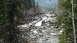
Otter Falls on Aishihik Lake Road
|
|
| Location | Yukon |
| Coordinates | 61°27′N 137°8′W / 61.450°N 137.133°W |
| Catchment area | 2,765 km2 (1,068 sq mi) |
| Basin countries | Canada |
| Surface area | 146 km2 (56 sq mi) |
| Average depth | 30 m (98 ft) |
| Max. depth | 120 m (390 ft) |
| Water volume | 4.38 km3 (1.05 cu mi) |
| Residence time | 14.6 years |
| Shore length1 | 153 km (95 mi) |
| Surface elevation | 914 m (2,999 ft) |
| 1 Shore length is not a well-defined measure. | |
Aishihik Lake is a lake in southwestern Yukon, Canada. Yukon Electric Corporation operates a 37 megawatt hydroelectric dam at the south end of the lake, where it drains southward into the Aishihik River.
A US Air Force base was established near the north part of the lake during World War II. The base used two Buda diesel engines to supply power and pump water.
Northern Mountain Caribou
The Aishihik and Kluane caribou herds migrate in the area surrounding Kluane and Aishihik Lakes. They are a northern mountain caribou, a distinct ecotype of the woodland caribou. In 2009 there were 181 caribou in the Kluane herd (also known as the Burwash herd) and 2044 caribou in the Aishihik herd. The Kluane herd was declining while the Aishihik herd was increasing.

All content from Kiddle encyclopedia articles (including the article images and facts) can be freely used under Attribution-ShareAlike license, unless stated otherwise. Cite this article:
Aishihik Lake Facts for Kids. Kiddle Encyclopedia.

