Ahumada Municipality facts for kids
Quick facts for kids
Ahumada
|
||
|---|---|---|
|
||

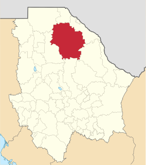
Municipality of Ahumada in Chihuahua
|
||
| Country | ||
| State | ||
| Founded | 1894 | |
| Named for | Miguel Ahumada | |
| Seat | Villa Ahumada | |
| Largest city | Villa Ahumada | |
| Area | ||
| • Total | 17,131.5 km2 (6,614.5 sq mi) | |
| Population
(2010)
|
||
| • Total | 11,457 | |
Ahumada is one of the 67 municipalities of Chihuahua, in northern Mexico. The municipal seat lies at Villa Ahumada. The municipality covers an area of 17,131.5 km2.
As of 2010, the municipality had a total population of 11,457, down from 11,727 as of 2005.
The municipality had 553 localities, the largest of which (with 2010 populations in parentheses) was: Villa Ahumada (8,575), classified as urban.
Geography
Towns and villages
| Name | Population (2005) |
|---|---|
| Villa Ahumada | 8,753 |
| Moctezuma | 129 |
| Ojo Caliente | 509 |
| Álamos de Peña | 326 |
| Carrizal | 102 |
| Total Municipality | 11,727 |
Villa Ahumada
Villa Ahumada (officially Miguel Ahumada) is a town and seat of the municipality of Ahumada in the state of Chihuahua in northern Mexico. It is located along Highway 45, about 130 km south of Ciudad Juárez and 247 km north of the city of Chihuahua. As of 2010, the town had a population of 8,575.
The city has several roadside restaurants and burrito stands and is known for its good cheese.
A number of small mining districts are located in the hills around Villa Ahumada, and the area is noted for its crystal specimens of wulfenite and other minerals.
Carrizal
Carrizal is a rural community located in Ahumada Municipality, Chihuahua, Mexico. It had a population of 102 inhabitants at the 2010 census, and is situated at an elevation of 1,120 meters above sea level.
Carrizal was founded November 26, 1772 as a Jesuit mission named San Fernando de las Amarillas del Carrizal. It was also the location of a presidio and civilian settlement, tasked to guard the route of the Camino Real de Tierra Adentro.
See also
 In Spanish: Municipio de Ahumada para niños


