Adrar Province facts for kids
Quick facts for kids
Adrar Province
ولاية أدرار
|
|
|---|---|

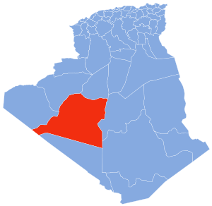
Map of Algeria highlighting Adrar
|
|
| Country | |
| Capital | Adrar |
| Area | |
| • Total | 439,700 km2 (169,800 sq mi) |
| Population
(2008)
|
|
| • Total | 402,197 |
| • Density | 0.91471/km2 (2.36908/sq mi) |
| Time zone | UTC+01 (CET) |
| Area Code | +213 (0) 49 |
| ISO 3166 code | DZ-01 |
| Districts | 11 |
| Municipalities | 28 |
Adrar is a province in southwestern Algeria. It is named for its capital Adrar. It is the second-largest province. There are 402,197 people.
Divisions
The province has 11 districts and 28 communes or municipalities.
Districts
- Adrar
- Aougrout
- Aoulef
- Bordj Badji Mokhtar
- Charouine
- Fenoughil
- Reggane
- T'Sabit
- Timimoun
- Tinerkouk
- Zaouiet Kounta
See also
 In Spanish: Provincia de Adrar para niños

All content from Kiddle encyclopedia articles (including the article images and facts) can be freely used under Attribution-ShareAlike license, unless stated otherwise. Cite this article:
Adrar Province Facts for Kids. Kiddle Encyclopedia.
