Adıyaman facts for kids
Quick facts for kids
Adıyaman
|
||
|---|---|---|
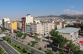
Atatürk Boulevard in Adıyaman
|
||
|
||
| Country | Turkey | |
| Province | Adıyaman | |
| District | Adıyaman | |
| Population
(2021)
|
267,131 | |
| Time zone | TRT (UTC+3) | |
Adıyaman (Kurdish: Semsûr) is a city in southeastern Turkey. It is the administrative centre of Adıyaman Province and Adıyaman District. Its population is 267,131 (2021). The inhabitants of the city are mostly Kurdish.
The city was one of the worst affected by the February 2023 Turkey-Syria earthquakes. Many buildings were destroyed and many lives lost in part because bad weather and damage to the transport infrastructure delayed the arrival of rescue teams.
Etymology
An unverified theory is that the former name of the city, Hisn-Mansur derives from the name of the Umayyad Emir Mansur ibn Jawana who was killed by the Abbasid Caliph Al-Mansur in this region in 758. Because of the difficulty among the locals in pronouncing Hisn-Mansur, the corruption Semsur emerged.
Various unverifiable theories exist for the name.
History
The first settlement on the site of the city was the ancient town of Perrhe, part of the kingdom of Commagene before it became part of the Roman and later Byzantine Empire.
It was then captured by the Arabs and became known as Hisn Mansur. It became a contested border town between the Abbasid caliphate and the Byzantines and was therefore well protected; a wall with three gates and a ditch guarded the town while in its middle stood a fortress with double walls.
In the early eleventh century, the town formed part of the Byzantine defences in the Euphrates region together with Edessa, Gargar, Samosata and Chasanara. In 1066/1067, the region around the town was ravaged by a Turkish emir called Gümüshtekīn who took booty and captives.
By the end of the eleventh century, the Byzantines had lost control of the town and it was now in possession of the Armenian local ruler Kogh Vasil.
Places of interest
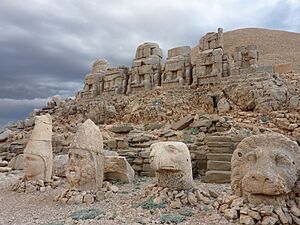
There is some passing tourist trade, the main tourist attraction being Mount Nemrut.
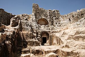
- The caves of Pirin (ancient city of Perre) are 5 km (3 mi). from Adıyaman. These have been used as a burial ground for thousands of years. The sights include the ruins of the city and burial caves carved into the rock.
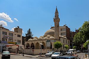
- The only active church in Adıyaman Province is located here, where it is the center of the Syriac Orthodox patriarchal vicarate of Adıyaman. It was renovated and reopened in 2012.
Climate
Adıyaman has a hot summer Mediterranean climate (Csa) under both the Köppen and Trewartha classifications, with some continental characteristics. Summers are very hot and very dry. Temperatures often reach 40 °C (104 °F) at the height of summer. The highest recorded temperature was 45.3 °C (113.5 °F) on 30 July 2000. Winters in Adıyaman are cool to cold with heavy precipitation. Due to its inland location and relatively high altitude, frost and snow are common. The lowest recorded temperature was −14.4 °C (6.1 °F) on 24 January 1972.
| Climate data for Adıyaman (1991–2020, extremes 1963–2024) | |||||||||||||
|---|---|---|---|---|---|---|---|---|---|---|---|---|---|
| Month | Jan | Feb | Mar | Apr | May | Jun | Jul | Aug | Sep | Oct | Nov | Dec | Year |
| Record high °C (°F) | 19.9 (67.8) |
23.8 (74.8) |
28.3 (82.9) |
34.5 (94.1) |
39.0 (102.2) |
43.0 (109.4) |
45.3 (113.5) |
45.2 (113.4) |
42.2 (108.0) |
36.1 (97.0) |
29.4 (84.9) |
26.5 (79.7) |
45.3 (113.5) |
| Mean daily maximum °C (°F) | 9.2 (48.6) |
10.9 (51.6) |
15.7 (60.3) |
21.1 (70.0) |
27.4 (81.3) |
34.1 (93.4) |
38.7 (101.7) |
38.6 (101.5) |
33.6 (92.5) |
26.3 (79.3) |
17.4 (63.3) |
11.1 (52.0) |
23.7 (74.7) |
| Daily mean °C (°F) | 5.0 (41.0) |
6.2 (43.2) |
10.4 (50.7) |
15.3 (59.5) |
20.9 (69.6) |
27.1 (80.8) |
31.5 (88.7) |
31.2 (88.2) |
26.2 (79.2) |
19.7 (67.5) |
11.9 (53.4) |
6.8 (44.2) |
17.7 (63.9) |
| Mean daily minimum °C (°F) | 1.8 (35.2) |
2.5 (36.5) |
5.9 (42.6) |
10.0 (50.0) |
14.7 (58.5) |
20.1 (68.2) |
24.1 (75.4) |
23.9 (75.0) |
19.4 (66.9) |
14.2 (57.6) |
7.6 (45.7) |
3.6 (38.5) |
12.3 (54.1) |
| Record low °C (°F) | −14.4 (6.1) |
−10.0 (14.0) |
−7.0 (19.4) |
−2.0 (28.4) |
3.4 (38.1) |
10.6 (51.1) |
15.0 (59.0) |
15.8 (60.4) |
9.6 (49.3) |
2.2 (36.0) |
−3.5 (25.7) |
−8.4 (16.9) |
−14.4 (6.1) |
| Average precipitation mm (inches) | 140.5 (5.53) |
107.1 (4.22) |
87.3 (3.44) |
61.7 (2.43) |
45.2 (1.78) |
9.4 (0.37) |
1.9 (0.07) |
2.5 (0.10) |
9.2 (0.36) |
48.6 (1.91) |
74.1 (2.92) |
142.0 (5.59) |
729.5 (28.72) |
| Average precipitation days | 12.37 | 11.77 | 11.47 | 11.3 | 8.4 | 3 | 0.8 | 0.67 | 1.63 | 6.8 | 8.3 | 11.7 | 88.2 |
| Average snowy days | 2.7 | 0.6 | 0.3 | 0 | 0 | 0 | 0 | 0 | 0 | 0 | 0 | 0.8 | 4.4 |
| Average relative humidity (%) | 66.4 | 64.4 | 57.9 | 55.1 | 47.6 | 33 | 27.5 | 29.4 | 33.3 | 45.5 | 59 | 67.4 | 48.9 |
| Mean monthly sunshine hours | 108.5 | 124.3 | 170.5 | 213.0 | 269.7 | 324.0 | 347.2 | 322.4 | 264.0 | 204.6 | 150.0 | 102.3 | 2,600.5 |
| Mean daily sunshine hours | 3.5 | 4.4 | 5.5 | 7.1 | 8.7 | 10.8 | 11.2 | 10.4 | 8.8 | 6.6 | 5.0 | 3.3 | 7.1 |
| Source 1: Turkish State Meteorological Service | |||||||||||||
| Source 2: NCEI(humidity), Meteomanz(snow days 2008-2023) | |||||||||||||
Neighbourhoods
The city has 33 quarters, including Esentepe.
See also
 In Spanish: Adıyaman para niños


