Aberdeen, Idaho facts for kids
Quick facts for kids
Aberdeen, Idaho
|
|
|---|---|

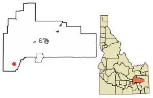
Location of Aberdeen in Bingham County, Idaho
|
|
| Country | United States |
| State | Idaho |
| County | Bingham |
| Incorporated | 1907 |
| Area | |
| • Total | 1.03 sq mi (2.67 km2) |
| • Land | 1.03 sq mi (2.67 km2) |
| • Water | 0.00 sq mi (0.00 km2) |
| Elevation | 4,403 ft (1,342 m) |
| Population
(2020)
|
|
| • Total | 1,756 |
| • Estimate
(2022)
|
1,832 |
| • Density | 1,779.0/sq mi (687.0/km2) |
| Time zone | UTC–7 (Mountain (MST)) |
| • Summer (DST) | UTC–6 (MDT) |
| ZIP Code |
83210
|
| Area code(s) | 208 and 986 |
| FIPS code | 16-00100 |
| GNIS feature ID | 2409654 |
Aberdeen is a city in Bingham County, Idaho, United States. The community was named after Aberdeen, in Scotland. The population was 1,756 at the 2020 census.
Contents
Geography
According to the United States Census Bureau, the city has a total area of 1.03 square miles (2.67 km2), all of it land.
Climate
Aberdeen has a semi-arid steppe climate (BSk) according to the Köppen climate classification system. The hottest temperature recorded in Aberdeen was 104 °F (40.0 °C) on July 21, 1931, July 28, 1934, and July 23, 2006, while the coldest temperature recorded was −42 °F (−41.1 °C) on January 19, 1922.
| Climate data for Aberdeen, Idaho, 1991–2020 normals, extremes 1914–present | |||||||||||||
|---|---|---|---|---|---|---|---|---|---|---|---|---|---|
| Month | Jan | Feb | Mar | Apr | May | Jun | Jul | Aug | Sep | Oct | Nov | Dec | Year |
| Record high °F (°C) | 56 (13) |
63 (17) |
76 (24) |
86 (30) |
96 (36) |
103 (39) |
104 (40) |
103 (39) |
100 (38) |
89 (32) |
73 (23) |
67 (19) |
104 (40) |
| Mean maximum °F (°C) | 45.2 (7.3) |
50.2 (10.1) |
64.9 (18.3) |
76.5 (24.7) |
84.6 (29.2) |
91.9 (33.3) |
97.8 (36.6) |
97.3 (36.3) |
91.1 (32.8) |
79.5 (26.4) |
62.8 (17.1) |
49.7 (9.8) |
99.0 (37.2) |
| Mean daily maximum °F (°C) | 32.2 (0.1) |
37.2 (2.9) |
48.3 (9.1) |
57.9 (14.4) |
67.7 (19.8) |
76.9 (24.9) |
87.1 (30.6) |
86.8 (30.4) |
76.4 (24.7) |
61.2 (16.2) |
45.1 (7.3) |
33.2 (0.7) |
59.2 (15.1) |
| Daily mean °F (°C) | 23.0 (−5.0) |
27.3 (−2.6) |
36.9 (2.7) |
44.3 (6.8) |
53.8 (12.1) |
61.4 (16.3) |
69.1 (20.6) |
67.7 (19.8) |
58.4 (14.7) |
45.8 (7.7) |
33.4 (0.8) |
23.8 (−4.6) |
45.4 (7.4) |
| Mean daily minimum °F (°C) | 13.8 (−10.1) |
17.4 (−8.1) |
25.6 (−3.6) |
30.8 (−0.7) |
39.8 (4.3) |
45.8 (7.7) |
51.1 (10.6) |
48.7 (9.3) |
40.4 (4.7) |
30.4 (−0.9) |
21.7 (−5.7) |
14.5 (−9.7) |
31.7 (−0.2) |
| Mean minimum °F (°C) | −7.1 (−21.7) |
−1.6 (−18.7) |
9.2 (−12.7) |
17.7 (−7.9) |
25.7 (−3.5) |
32.9 (0.5) |
40.3 (4.6) |
37.1 (2.8) |
27.3 (−2.6) |
15.9 (−8.9) |
3.5 (−15.8) |
−6.3 (−21.3) |
−12.5 (−24.7) |
| Record low °F (°C) | −42 (−41) |
−38 (−39) |
−22 (−30) |
−7 (−22) |
15 (−9) |
22 (−6) |
31 (−1) |
29 (−2) |
9 (−13) |
−3 (−19) |
−16 (−27) |
−32 (−36) |
−42 (−41) |
| Average precipitation inches (mm) | 0.85 (22) |
0.64 (16) |
0.85 (22) |
0.87 (22) |
1.17 (30) |
0.99 (25) |
0.41 (10) |
0.42 (11) |
0.83 (21) |
0.90 (23) |
0.66 (17) |
0.99 (25) |
9.58 (244) |
| Average snowfall inches (cm) | 7.7 (20) |
5.1 (13) |
1.8 (4.6) |
0.5 (1.3) |
0.1 (0.25) |
0.0 (0.0) |
0.0 (0.0) |
0.0 (0.0) |
0.0 (0.0) |
0.5 (1.3) |
2.0 (5.1) |
7.5 (19) |
25.2 (64.55) |
| Average precipitation days (≥ 0.01 in) | 7.9 | 6.5 | 6.1 | 6.7 | 7.5 | 5.3 | 3.6 | 3.8 | 4.8 | 5.7 | 5.7 | 8.4 | 72.0 |
| Average snowy days (≥ 0.1 in) | 5.1 | 3.6 | 1.0 | 0.4 | 0.0 | 0.0 | 0.0 | 0.0 | 0.0 | 0.2 | 1.4 | 5.5 | 17.2 |
| Source 1: NOAA | |||||||||||||
| Source 2: National Weather Service | |||||||||||||
Demographics
| Historical population | |||
|---|---|---|---|
| Census | Pop. | %± | |
| 1920 | 471 | — | |
| 1930 | 646 | 37.2% | |
| 1940 | 1,016 | 57.3% | |
| 1950 | 1,486 | 46.3% | |
| 1960 | 1,484 | −0.1% | |
| 1970 | 1,542 | 3.9% | |
| 1980 | 1,528 | −0.9% | |
| 1990 | 1,406 | −8.0% | |
| 2000 | 1,840 | 30.9% | |
| 2010 | 1,994 | 8.4% | |
| 2020 | 1,756 | −11.9% | |
| 2022 (est.) | 1,832 | −8.1% | |
| U.S. Decennial Census 2020 Census |
|||
2020 census
As of the 2020 census, there were 1,756 people and 741 households residing in the city.
2010 census
As of the 2010 census, there were 1,994 people, 615 households, and 466 families residing in the city. The population density was 1,935.9 inhabitants per square mile (747.5/km2). There were 667 housing units at an average density of 647.6 per square mile (250.0/km2). The racial makeup of the city was 60.2% White, 0.1% African American, 0.7% Native American, 0.1% Asian, 37.5% from other races, and 1.5% from two or more races. Hispanic or Latino of any race were 54.1% of the population.
There were 615 households, of which 49.6% had children under the age of 18 living with them, 59.0% were married couples living together, 10.6% had a female householder with no husband present, 6.2% had a male householder with no wife present, and 24.2% were non-families. 20.0% of all households were made up of individuals, and 10.7% had someone living alone who was 65 years of age or older. The average household size was 3.24 and the average family size was 3.79.
The median age in the city was 28.1 years. 37.2% of residents were under the age of 18; 8.7% were between the ages of 18 and 24; 24.2% were from 25 to 44; 19.8% were from 45 to 64; and 10.1% were 65 years of age or older. The gender makeup of the city was 50.6% male and 49.4% female.
Education
Aberdeen Public Schools are part of the Aberdeen School District #58. Schools located in the district include Aberdeen Elementary School, Aberdeen Middle School and Aberdeen High School.
The University of Idaho's Aberdeen Research and Extension Center is located near the town.
C.J. Ward is the Superintendent of Schools.
Transportation
Airport
Aberdeen Municipal Airport is a city-owned public-use airport located two nautical miles (3.7 km) southwest of the central business district of Aberdeen.
See also
 In Spanish: Aberdeen (Idaho) para niños


