Aïn Defla Province facts for kids
Quick facts for kids
Aïn Defla Province
ولاية عين الدفلى
|
|
|---|---|

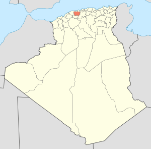
Map of Algeria highlighting Aïn Defla
|
|
| Country | |
| Capital | Aïn Defla |
| Area | |
| • Total | 4,897 km2 (1,891 sq mi) |
| Population
(2008)
|
|
| • Total | 771,890 |
| • Density | 157.625/km2 (408.25/sq mi) |
| Time zone | UTC+01 (CET) |
| Area Code | +213 (0) 27 |
| ISO 3166 code | DZ-44 |
| Districts | 14 |
| Municipalities | 36 |
Aïn Defla is a province in northern Algeria. It is southwest of Algiers, the capital. Towns in Ain Delfa include Miliana, Hammam Righa, and Aïn Torki.
Administrative divisions
The province has 14 districts and 36 municipalities.
The districts are:
- Aïn Defla
- Aïn Lechiakh
- Bathia
- Bordj El Amir Khaled
- Boumedfaâ
- Djendel
- Djelida
- El Abadia
- El Amra
- El Attaf
- Hammam Righa
- Khemis
- Miliana
- Rouina
See also
 In Spanish: Provincia de Aín Defla para niños

All content from Kiddle encyclopedia articles (including the article images and facts) can be freely used under Attribution-ShareAlike license, unless stated otherwise. Cite this article:
Aïn Defla Province Facts for Kids. Kiddle Encyclopedia.
