2010 Pichilemu earthquake facts for kids

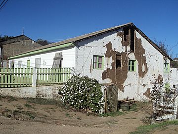
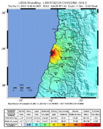
Above: House damaged by the Pichilemu earthquake, in the epicentre town, as seen on 16 April 2011. Below: Pichilemu earthquake shakemap produced by the United States Geological Survey
|
|
 |
|
| UTC time | Doublet earthquake: |
|---|---|
| 2010-03-11 14:39:43 | |
| 2010-03-11 14:55:27 | |
| ISC event | |
| 14554049 | |
| 14400686 | |
| USGS-ANSS | |
| ComCat | |
| ComCat | |
| Local date | 11 March 2010 |
| Local time | |
| 11:39 UTC-3 | |
| 11:55 UTC-3 | |
| Magnitude | |
| 6.9 Mw 6.3 ML |
|
| 7.0 Mw | |
| Depth | 33.1 kilometres (20.6 mi) |
| Epicenter | Pichilemu, Chile 34°18′04″S 72°07′48″W / 34.301°S 72.13°W |
| Areas affected | Chile Argentina |
| Max. intensity | MM X |
| Peak acceleration | 0.086g (Curicó, Maule) |
| Tsunami | Yes |
| Casualties | 1 killed |
A 6.9 earthquake occurred on March 11, 2010, 40 kilometers southwest of Pichilemu, O'Higgins Region, Chile . A tsunami warning was made by the Pacific Tsunami Warning Center Pacific-wide, although they warned of the possibility of local tsunamis within 100 kilometers of the epicenter (between San Antonio and Concepción).
Although news media first reported the earthquake as an aftershock of the February earthquake, the initial geological summary given by the United States Geological Survey said it was a different earthquake. Though unchained by the regional stress caused by the February 27 earthquake, the March event was not a fast adjustment to February's thrust fault rupture between the Nazca and South American plates, but it was caused by normal faulting inside one of those plates. However, it has not been positively decided in which plate the earthquake occurred.
Within 6 hours, 10 aftershocks took place, of these 2 were of magnitude 6 or greater and 7 between magnitude 5 and 6.
The earthquake took place shortly before the new president, Sebastián Piñera, was sworn in, at about 12:15 PM local time (15:15 UTC), at the Chilean congress in Valparaíso, where the shaking was clearly felt. The presidents of Bolivia, Paraguay, and Ecuador were present when the earthquake occurred, however, the television footage showed that the inauguration was not interrupted.
Damages reported by the Chilean news media include a collapsed pedestrian crossing over Chile Highway 5, north of Rancagua. The most affected place by the earthquake was Pichilemu, the epicentre of the earthquake. It destroyed the Ross Park, the most of the Agustín Ross Cultural Centre and many houses in Espinillo and Rodeillo.
May 2, 2010 aftershock
The May, 2 2010 Pichilemu earthquake was a magnitude 6.0 MW earthquake that struck off Pichilemu, Chile, at 10:52 AM on May 2, 2010 at the epicenter, at a depth of 31 kilometres (19 mi). USGS described that the epicenter was 70 kilometres (43 mi) south-southwest of San Antonio, 105 kilometres (65 mi) west Regional capital of Rancagua, 105 kilometres (65 mi) northwest of Curicó and 140 kilometres (87 mi) southwest of the Chilean capital of Santiago.
After almost exactly three hours later a second quake happens in the same area with an intensity of 4.8 MW
More than 10 aftershocks happened on May 2 and 3.
Related pages
Images for kids
-
The city of Pichilemu suffered major damage in the 27 February 2010 earthquake and tsunami.
-
The earthquakes took place just minutes before President Sebastián Piñera was sworn in at the National Congress of Chile.
-
Army personnel at La Cruz Hill, Pichilemu, shortly after the earthquake occurred.
-
The New York Times included a headline on their 12 March 2010 main page titled "For Chile, More Aftershocks and An Inauguration", featuring a photograph of presidents Lugo and Correa during one of the earthquakes
See also
 In Spanish: Terremoto de Pichilemu de 2010 para niños


