1964 Alaska earthquake facts for kids

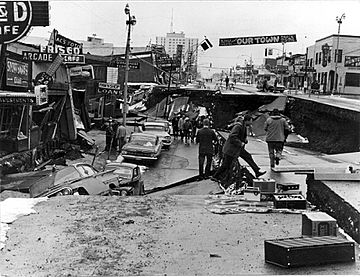
Fourth Avenue in Anchorage, Alaska, looking east from near Barrow Street. The southern edge of one of several landslides in Anchorage, this one covered an area of over a dozen blocks, including five blocks along the north side of Fourth Avenue. Most of the area was razed and made an urban renewal district.
|
|
 |
|
| UTC time | 1964-03-28 03:36 |
|---|---|
| ISC event | 869809 |
| USGS-ANSS | ComCat |
| Local date | March 27, 1964 |
| Local time | 17:36:16 AKST |
| Duration | 4–5 minutes. |
| Magnitude | 9.2 Mw, 6.7 mb (ISC) |
| Depth | 25 kilometers (16 mi) |
| Epicenter | 60°54′29″N 147°20′20″W / 60.908°N 147.339°W |
| Type | Megathrust |
| Areas affected | United States, Canada |
| Total damage | $311 million (1964 USD) |
| Max. intensity | XI (Extreme) |
| Peak acceleration | 0.18 g |
| Tsunami | Major. Run-up of 67 m (220 ft) at Shoup Bay, Alaska. |
| Casualties | 131 killed |
The 1964 Alaskan earthquake, also known as the Great Alaskan earthquake and Good Friday earthquake, happened at 5:36 PM AKST on Good Friday, March 27, 1964. Across south-central Alaska (mainly in Anchorage), ground fissures, collapsing structures, and tsunamis were caused by the earthquake. It caused about 131 deaths.
The earthquake lasted four minutes and thirty-eight seconds. It was a magnitude 9.2 earthquake. It remains the most powerful earthquake recorded in North American history, and the second most powerful earthquake recorded in world history.
Nearby, a 27-foot (8.2 m) tsunami destroyed the village of Chenega, killing 23 of the 68 people who lived there. Post-quake tsunamis severely affected Whittier, Seward, Kodiak, and other Alaskan communities, as well as people and property in British Columbia, Washington, Oregon, and California.
Tsunamis also caused damage in Hawaii and Japan. Evidence of motion directly related to the earthquake was also reported from Florida and Texas.
Images for kids
-
The largest landslide in Anchorage occurred along Knik Arm between Point Woronzof and Fish Creek, causing substantial damage to numerous homes in the Turnagain-By-The-Sea subdivision.
-
The ruin of Portage
-
A plank driven through a tire by the tsunami in Whittier
-
The 5-story JCPenney department store in Anchorage in 1964, following the earthquake.
-
The Valdez townsite was abandoned and relocated following the 1964 earthquake and was used as a pipe yard for the construction of the Trans-Alaska Pipeline System, as shown in this 1974 photo
See also
 In Spanish: Terremoto de Alaska de 1964 para niños


